
Lake Superior geology is truly unusual and unexpected as well. Recall that a billion years ago pretty well puts you before life took over on earth or in the precambrian which describes the whole Canadian shield.
What is so extraordinary is that we have massive near surface ore bodies of native copper which is rare world wide and easily mined out when encountered. It is created by the reduction of sulphides through near surface weathering and possibly in the Precambrian.
That oddity supported a thousand years of Bronze Age copper trade and millions of pounds were mined in thousands of pit mines. The archeology has been long done including Minion artyifacts lodged in a university cellar. The trade itself linked into the Atlantic Great Circle route from Bimini to Lewis to Gibaulter and back to Bimini. Navigation only needs latitude to be safe.
How to explore a billion-year-old volcanic mystery along Lake Superior
The Upper Midwest once teemed with fiery geologic activity. You can still see traces of it in cascading waterfalls, red sandstone sea caves, and towering cliffs.
A kayaker paddles into a sea cave in the Apostle Islands National Lakeshore in Bayfield, Wisconsin. The area was once teeming with volcanic activity. PHOTOGRAPH BY DAVID GUTTENFELDER
BYJACQUELINE KEHOE
PUBLISHED FEBRUARY 23, 2023
https://www.nationalgeographic.com/travel/article/volcanic-mystery-lake-superior-upper-midwest?ref=refind
A billion years ago, if you’d looked out from the top of Michigan’s now densely forested Summit Peak, you’d have seen a fiery, volcano-lit battleground. Steaming fissures, molten rocks, and lava flows dominated the landscape.
The dramatic scene was caused by one of the Earth’s grandest volcanic events. “Around 1.1 billion years ago,” says Esther Stewart, a geologist for the Wisconsin Geological and Natural History Survey, “the continent we call North America started to rip apart.” The Midcontinent Rift caused a nearly 1,300-mile horseshoe-shaped gash from Lake Superior west to modern-day Kansas and east toward Ohio.
Driving along Lake Superior, from Michigan through Wisconsin into Minnesota, visitors can retrace the results of this billion-year-old story via cascading waterfalls, red sandstone sea caves, and towering cliffs. It’s a hidden landscape for most travelers to the Midwest—unless you know what to look for.
A molten history
Geologists agree the Midcontinent Rift was caused by a mantle plume—a chimney of extra-hot rock that rises from deep in the Earth’s interior, stretching the land above until it breaks—similar to how Hawaii was formed. (Imagine a wax bubble inside a lava lamp rising—then splitting the bubble above). The rift largely produced flows of basalt, runny lava that formed low-lying shield volcanoes. “You’d have fissures, these big long cracks,” Stewart says. “They might have been kilometers long with this runny basalt lava coming out of them.”

A cyclist takes in the scenery at Michigan’s Porcupine Mountains Wilderness State Park. Travelers can find traces of the Midcontinent Rift along the steep-sloped ridges running parallel to Lake Superior’s shore.PHOTOGRAPH BY CHRISTIAN HEEB, LAIF/REDUX
But unlike most basalt flows—such as the Columbia River basalts covering Washington State—the lava didn’t make it far. “The Lake Superior area is a very unusual case,” says Tyrone Rooney, professor of igneous petrology and geochemistry at Michigan State University. “Most of the time, flood basalts erupt onto a flat area and then spread out.” Instead, he describes how these lavas filled up an existing basin and created stacks of basalt much thicker than average. The Greenstone Flow alone pooled to some 1,600 feet deep. “It was so massive that it differentiated within the rift. You can see it across the green and black rocks of the Keweenaw Peninsula. It’s a fascinating place.”
Some geologists, including Stewart, argue mountain formations to the east reversed the rift; others, like Rooney, believe it was the continent moving at high speeds—much faster than today’s fingernail-esque pace. “When you do that sort of movement,” he argues, “it does all sorts of things to the mantle beneath. It’s still an area of active research.”
Regardless of the reasons why, over roughly 30 million years, the Midcontinent Rift produced more than 240,000 cubic miles of volcanic rock—44 times the volume of all the Great Lakes combined.
Now imagine what we’d see if the water weren’t there.
“Below Lake Superior, it’s insane,” says George Hudak. The senior geologist at the University of Minnesota Natural Resources Research Institute describes how tens of kilometers of sedimentary rocks piled into the rift as it opened up, covering a molten, volcanic sea. “This was one of the biggest magmatic events to ever occur on Earth,” he says.
Those sediments would become important, too—they’re responsible for beloved spots like the Apostle Islands and Pictured Rocks National Lakeshore.
On the path of volcanoes
Today, volcano-chasers in Michigan can head from the rhyolite-rich Porcupine Mountains up to the tip of the Keweenaw Peninsula, via M-41 to Copper Harbor, to see lava flows visible in the roadcuts. Rooney adds that, across Michigan’s Upper Peninsula, visitors can discover stromatolites, the oldest known fossils. “If you look at some of these conglomerates, you can see odd layers. Some of these layers are actually early forms of very small life.”
At High Rock Bay, on the peninsula’s tip, travelers can see where these conglomerate layers made contact with lava flows—the tops of flows are where to look for the region’s sought-after agates.
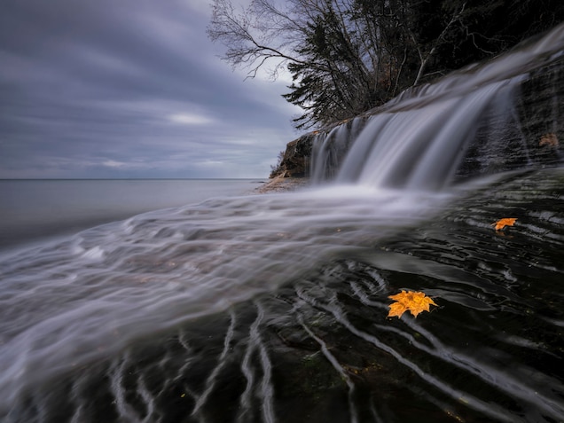
Elliot Falls cascades over a cliff into Lake Superior, where tens of kilometers of sedimentary rocks from previous volcanic activity helped form Pictured Rocks National Lakeshore.PHOTOGRAPH BY KIETH LADZINSKI, NAT GEO IMAGE COLLECTION
From Michigan, volcanology fans can road trip west along Wisconsin’s northern coast to Potato River Falls and Copper Falls State Park, “where you can walk from the volcanics into the sedimentary rock,” says Stewart. Other Wisconsin spots include the Saint Croix National Scenic Riverway; Pattison State Park, home to Wisconsin’s tallest waterfall; and Interstate State Park, where the St. Croix River churns through a deep basalt gorge.
Then it’s up to Duluth and Minnesota’s North Shore, where things get truly wild. “Just driving around Duluth you can see some of the earliest intrusions associated with the Midcontinent Rift, layered just like sedimentary rocks,” says Hudak. He recommends visiting Leif Erikson Park, where “you can actually see pahoehoe lava flows, like Hawaii and Iceland”; Tettegouche State Park’s Palisade Head, where more explosive rhyolite formed columns great for rock-climbing; and Gooseberry Falls, where a series of lava flows have built up five waterfalls and walkable spots like Picnic Flow.
“My favorite spot,” Hudak adds, “is a mile east of Spirit Mountain, in Duluth. You can actually stand under lava flow number one—the first lava flow associated with this world-changing event. Talk about spectacular.”
No comments:
Post a Comment