What comes out of this is a clear tightening of our geological knowledge around the plate tectonic model. Understand that sixty years ago we had none of this and instead had models that beggered belief and even defied physics.
This model is still deeply limited, but still hands off to rock depth and natural chemistry. I doubt that we will do better. The major problem with our geology is that all rock ages are deemed measurable and those are then associated with the age of tectonic breaks.
It should be obvious that a fracture in a sediment stack that is millions of years old merely tells us that the fracture postdates the laying down of those sediments. Such a fracture could be literally super recent. I say this because i have seen fracture faces that were amazingly stable with scant talus at their foot. Yet such rock weathers far faster than you imagine. all this begs the question of time.
Throw in my Pleistocene Nonconformity and 13,000 BP is very recent compared to far less disturbed topography with its deep rotting rock..
.
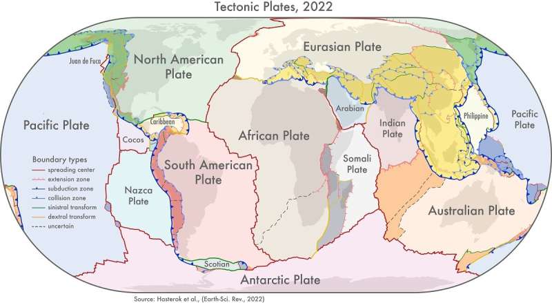
New maps of global geological provinces and tectonic plates
Credit: Dr. Derrick Hasterok, University of Adelaide
https://phys.org/news/2022-06-global-geological-provinces-tectonic-plates.html
New models that show how the continents were assembled are providing fresh insights into the history of the Earth and will help provide a better understanding of natural hazards like earthquakes and volcanoes.
"We looked at the current knowledge of the configuration of plate boundary zones and the past construction of the continental crust," said Dr. Derrick Hasterok, Lecturer, Department of Earth Sciences, University of Adelaide who led the team that produced the new models.
"The continents were assembled a few pieces at a time, a bit like a jigsaw, but each time the puzzle was finished it was cut up and reorganized to produce a new picture. Our study helps illuminate the various components so geologists can piece together the previous images.
"We found that plate boundary zones account for nearly 16% of the Earth's crust and an even higher proportion, 27%, of continents."
The team produced three new geological models: a plate model, a province model and an orogeny model.
"There are 26 orogenies—the process of mountain formation—that have left an imprint on the present-day architecture of the crust. Many of these, but not all, are related to the formation of supercontinents," said Dr. Hasterok.
"Our work allows us to update maps of tectonic plates and the formation of continents that are found in classroom textbooks. These plate models which have been assembled from topographic models and global seismicity, have not been updated since 2003."
The new plate model includes several new microplates including the Macquarie microplate which sits south of Tasmania and the Capricorn microplate that separates the Indian and Australian plates.
"To further enrich the model, we added more accurate information about the boundaries of deformation zones: previous models showed these as discrete areas rather than wide zones," said Dr. Hasterok.
"The biggest changes to the plate model have been in western North America, which often has the boundary with the Pacific Plate drawn as the San Andreas and Queen Charlotte Faults. But the newly delineated boundary is much wider, approximately 1,500 km, than the previously drawn narrow zone.
"The other large change is in central Asia. The new model now includes all the deformation zones north of India as the plate bulldozes its way into Eurasia."
Published in the journal Earth-Science Reviews, the team's work provides a more accurate representation of the Earth's architecture and has other important applications.
"Our new model for tectonic plates better explains the spatial distribution of 90% of earthquakes and 80% of volcanoes from the past two million years whereas existing models only capture 65% of earthquakes," said Dr. Hasterok.
"The plate model can be used to improve models of risks from geohazards; the orogeny model helps understand the geodynamic systems and better model Earth's evolution and the province model can be used to improve prospecting for minerals."
No comments:
Post a Comment