
However my own investigations have developed a remarkably similar model in terms of alternate geologies and prospective land masses. It is just that the actual locations can now be precisely defined and they are certainly plausible.
In the Atlantic we have an uplifted mid Atlantic ridge which nicely allows at least two large islands. One of these is Lyonese west of Ireland and similar in size. The second is Atlantis at the Azores and about the size of Britain. Both could host large populations in deep sea based security. At the same time Britain was still likely connected by land to Europe.
That same uplift brought the Bahama bank well above sea level as well and this is a land mass similar to France. Add in the Cuban ridge as well and we have a land mass the size of Japan.
All this was excellent country in which to establish a sea based culture as described for Atlantis itself. Plenty of land and space for a robust and secure population.
Then we tackle Mu itself and there we simply go the South China sea and the Indonesian archipelago whose scope equals that of the USA. It was first inundated and then submerged by rising sea levels in the three to four thousand years after the Pleistocene Nonconformity. sufficient land mass actually existed.
Churchward was informed by the terribly wrong geology of his day and really cannot be blamed for his natural errors in location. Yet his cultural sources actually look much better as Mu is then convenient to India from which he extracted his information. All good.
Now we get down to the nut cracker. I have suggested that the Pleistocene Nonconformity caused local compression and also local stretching. The crust shifted after all over an imperfect sphere. Natural compression just happens to coincide with the Andes and the Himalayas. I would also like to say that prior to this crustal movement, which was deliberately arranged, most mountain ranges were like the Appalachians and well eroded. Thus the whole ring of fire saw serious compression as did the Alps and the intervening lands to the Himalayas.
It is thus perfectly plausible that South America lacked a significant mountain barrier on its west coast a mere 12,900 years ago. An uplift would have drained any internal sea and allowed the basin to then be populated by the surrounding rain-forest.
Our problem is that Geologists are aging geology against the age of rocks. Not a bad idea provided nothing really happens. Yet when miles of rock are thrown skyward, there is no plausible way to secure an event date. All those rocks are still millions of years old and the real movement planes are all deeply buried as well. Scarring also gets eroded down and buried pretty quickly as well. 12900 years is ample to hide surface effects.
So no one is going to accept Churchward's cultural sources or my projected genesis of our mountains unless they also accept the actual shift of our crust 12,900 years ago. That is a pretty tall order. Yet do understand that the global evidence portfolio supports all this without a meaningful anomaly. Right now geologists are slowly crawling toward accepting the comet hitting the Northern Ice Cap 12900 BP. No one has woken up to the crustal shift or that the comet was right on target in order to end the Ice Age. Yet i said all this publicly a decade ago.
I do note that we can assume that the western edge of South America did have an Appalachian like range which fed sediments into the amazon basin. Like Our own Appalachians it was easily plausible for rivers and canals to cut this barrier range. Thus the obvious objections from modern geology are no objections at all. The same held true for the Himalayas. In both cases already established ranges were hurled vastly higher than possible.
I really would love to see someone drive tunnels to the base of some of those long scree slopes in order to locate carbon that can be aged..
.
New Findings Concerning the Amazonian Sea
Posted on March 26, 2017 | Leave a comment
http://blog.my-mu.com/?p=2589
Readers of James Churchward’s works will remember his theories of the recent raising of the mountains and the draining of the Amazonian Sea in South America.
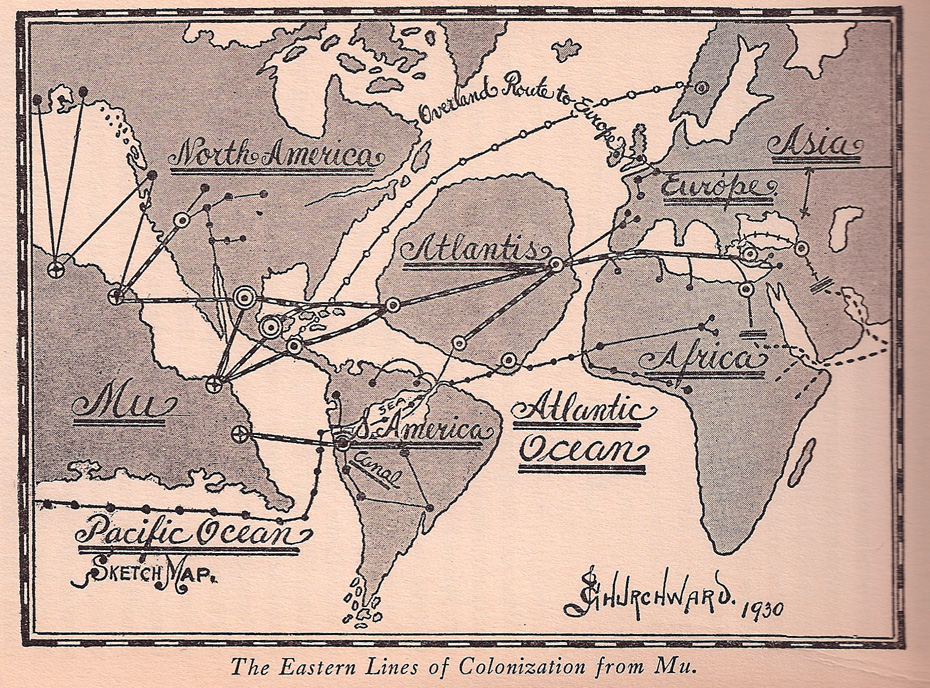
From Children of Mu, page 22
THE ANCIENT.—And now, to me, comes the most fascinating part of South American history—the distant past. Strange as it may appear to us today, the fact remains that in ancient times South America played an important part in peopling the world, for she was the road or passageway that two important lines of colonists took going from the Motherland in easterly directions. The topography of South America today is totally different from what it was 20,000 years ago, the time when droves of Carians, or Karians, and Negro colonists were leaving the Motherland to find new homes and more room upon the earth. When this exodus from the Motherland commenced we have not as yet been told, but there are various records of emigration some 35,000 years ago and others 70,000 years ago. Then South America was like the rest of the world—flat and without mountains—for up to less than 15,000 years back no mountains had been raised to protect man from constant destructions by cataclysms and submersions, nor could there possibly be until after the earth went into Final Magnetic Balance.
What is now the Amazon Valley, which is intended to include the Amazon Swamp and the Amazonian watershed, was then an equally large land-locked Sea like the Mediterranean Sea today. The Amazonian Sea at its eastern end was connected with the Atlantic Ocean and at its western end with the Pacific Ocean by canals. These canals were intact up to the time the mountains were raised. There was an uninterrupted waterway between the Motherland and Atlantis, West Africa, and even as far as Asia Minor at the eastern end of the Mediterranean. The shore lines of this Amazonian Sea are very distinctly marked today: the northern shores were along the foothills of the Venezuelan highlands; along this shore line are some wonderful white quartz beaches. The southern shores are along the foothills of the Pan Alto Mountains. The eastern shores are along a mountainous spur that runs into the Pan Alto, and the western shores are along the eastern foothills of the Andes.
My attention was first called to this Amazonian Sea by one of the before- mentioned tablet maps in the monastery in Tibet. I discovered that these maps were dated. Their dates were given by the position of certain stars in certain constellations.
Children of Mu, pages 90-91

Colorized map seen by Churchward in Tibetan monastery
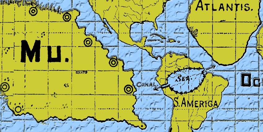
Colorized map seen by Churchward in Tibetan monastery – with closeup on Amazonian Sea
Unfortunately, a new study has shown the Amazon River is no younger than 9 million (9,000,000) years old by examining the contents of hydrocarbon exploration boreholes. The evidence clearly shows the change in sediment composition and plant residue from 9.4 to 9 million years ago switching from the tropical lowlands to the high Andes Mountains.
The new study shows James’ age of orogeny (it is the word of the day) is completely off-base. Mountains took millions of years to be created and did not pop up ‘overnight’ in geological terms.
SHARE THIS:
No comments:
Post a Comment