Showing posts with label Arctic Gyre. Show all posts

Tuesday, August 11, 2009

Current Sea Ice August 2009

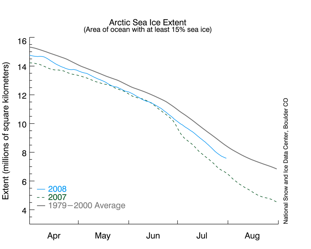
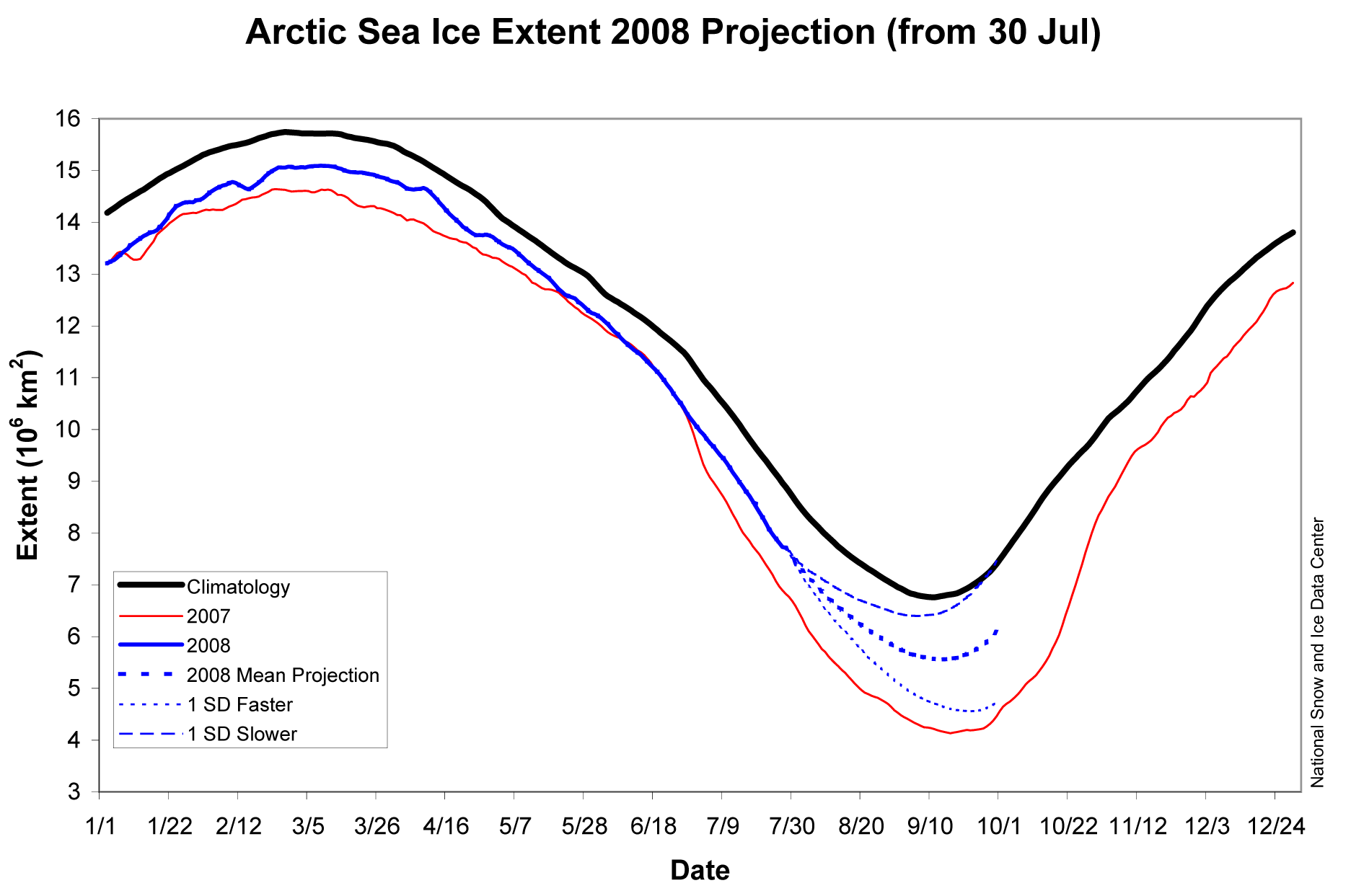
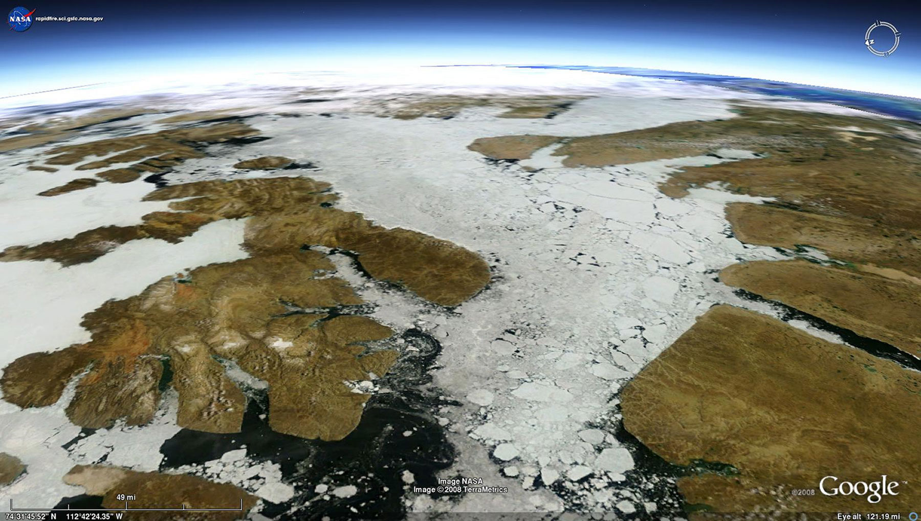
When I last posted on the sea ice thirty days ago, I noted that it had taken a sudden dip making a repeat of 2007 possible. Well here we are and it is certainly going to be close.

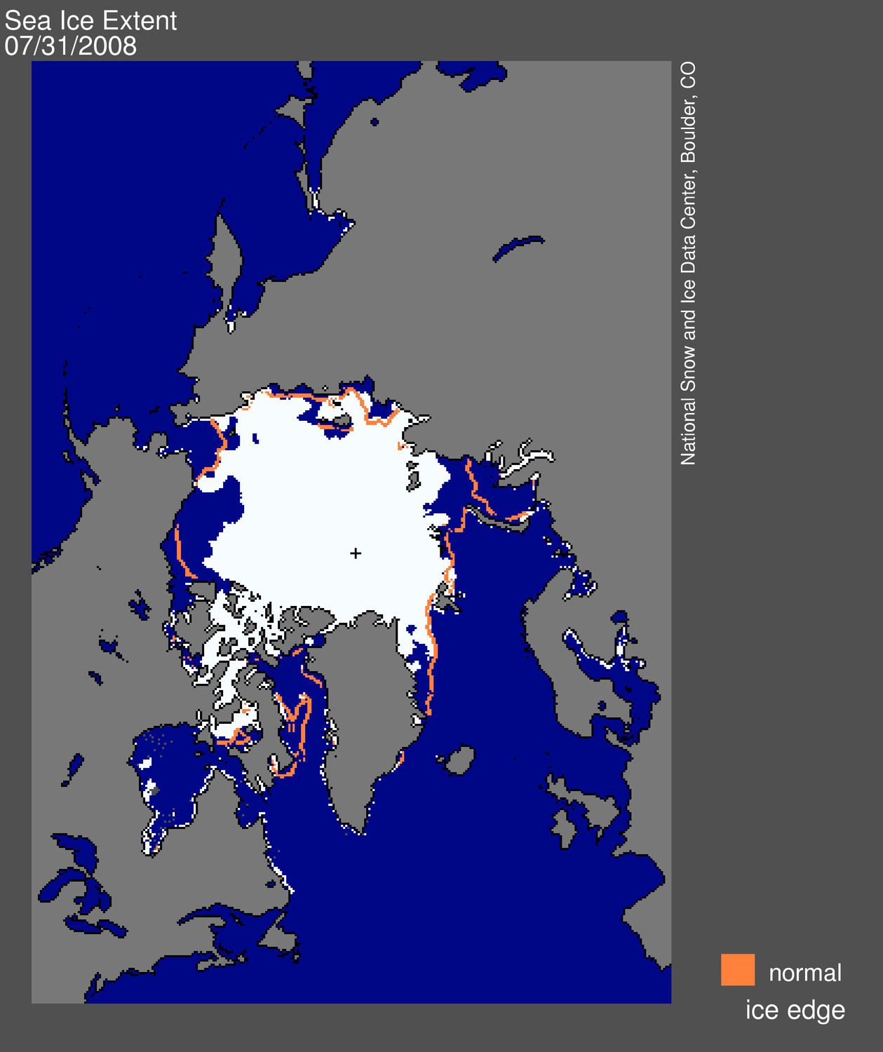
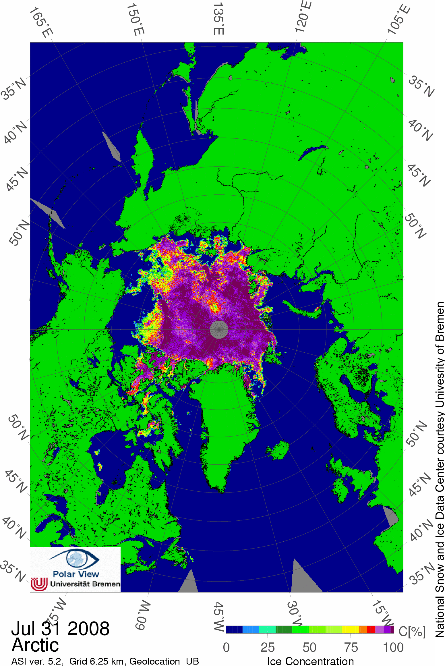
It may not be as energetic as 2007 but there is less to work on so it is easier to get the same result. I have included the link to the map I like and it is just updated. The North East passage is wide open except at the usual chokepoint. The North West passage is choked with broken multi year ice busily melting and will not likely clear this year. I got that right also.

Once again folks are standing on a very few remaining feet of ice that is disappearing at the rate of six inches per year and stating that we have twenty or more years to wait. At least they are not claiming today that it will take ninety years.

The remaining question is the present state of the multi year ice in the main intact bulk of the sea ice. This zone is large, but all the peripheral ice looks to disappear pretty quickly. It now becomes important to discover what is meant by sixty percent and the like. If the core is still holding up, then it has a ways to go before it finally breaks up. We will still have wide open passages, but possible injection of some thick ice depending on winds.

The destruction of all thick ice will open the passages to icebreaker supported shipping most years.

There is now a lot that we do not know. It has been stated that the ice travels through the Arctic gyre. This may simply be not true. In that case, thick ice can linger in cold spots and avoid breakup. Fine modeling may show that a portion of the sea ice may be retained in a sub gyre that preferentially holds it for several years even if everything else gets melted.

The point today is that it is timely to ask these questions. A strong sub gyre could retain a significant pool of sea ice long after everything else has been cleared out. And I certainly do not count on anyone having mapped it very much.

Vast expanses of Arctic ice melt in summer heat

TUKTOYAKTUK, Northwest Territories — The Arctic Ocean has given up tens of thousands more square miles (square kilometers) of ice on Sunday in a relentless summer of melt, with scientists watching through satellite eyes for a possible record low polar ice cap.

From the barren Arctic shore of this village in Canada's far northwest, 1,500 miles (2,414 kilometers) north of Seattle, veteran observer Eddie Gruben has seen the summer ice retreating more each decade as the world has warmed. By this weekend the ice edge lay some 80 miles (128 kilometers) at sea.

"Forty years ago, it was 40 miles (64 kilometers) out," said Gruben, 89, patriarch of a local contracting business.

Global average temperatures rose 1 degree Fahrenheit (0.6 degree Celsius) in the past century, but Arctic temperatures rose twice as much or even faster, almost certainly in good part because of manmade greenhouse gases, researchers say.

In late July the mercury soared to almost 86 degrees Fahrenheit (30 degrees Celsius) in this settlement of 900 Inuvialuit, the name for western Arctic Eskimos.

"The water was really warm," Gruben said. "The kids were swimming in the ocean."

As of Thursday, the U.S. National Snow and Ice Data Center reported, the polar ice cap extended over 2.61 million square miles (6.75 million square kilometers) after having shrunk an average 41,000 square miles (106,000 square kilometers) a day in July -- equivalent to one Indiana or three Belgiums daily.

The rate of melt was similar to that of July 2007, the year when the ice cap dwindled to a record low minimum extent of 1.7 million square miles (4.3 million square kilometers) in September.

In its latest analysis, the Colorado-based NSIDC said Arctic atmospheric conditions this summer have been similar to those of the summer of 2007, including a high-pressure ridge that produced clear skies and strong melt in the Beaufort Sea, the arm of the Arctic Ocean off northern Alaska and northwestern Canada.

In July, "we saw acceleration in loss of ice," the U.S. center's Walt Meier told The Associated Press. In recent days the pace has slowed, making a record-breaking final minimum "less likely but still possible," he said.

Scientists say the makeup of the frozen polar sea has shifted significantly the past few years, as thick multiyear ice has given way as the Arctic's dominant form to thin ice that comes and goes with each winter and summer.

The past few years have "signaled a fundamental change in the character of the ice and the Arctic climate," Meier said.

Ironically, the summer melts since 2007 appear to have allowed disintegrating but still thick multiyear ice to drift this year into the relatively narrow channels of the Northwest Passage, the east-west water route through Canada's Arctic islands. Usually impassable channels had been relatively ice-free the past two summers.

"We need some warm temperatures with easterly or southeasterly winds to break up and move this ice to the north," Mark Schrader, skipper of the sailboat "Ocean Watch," e-mailed The Associated Press from the west entrance to the passage.

The steel-hulled sailboat, with scientists joining it at stops along the way, is on a 25,000-mile (40,232-kilometer), foundation-financed circumnavigation of the Americas, to view and demonstrate the impact of climate change on the continents' environments.

Environmentalists worry, for example, that the ice-dependent polar bear will struggle to survive as the Arctic cap melts. Schrader reported seeing only one bear, an animal chased from the Arctic shore of Barrow, Alaska, that "swam close to Ocean Watch on its way out to sea."

Observation satellites' remote sensors will tell researchers in September whether the polar cap diminished this summer to its smallest size on record. Then the sun will begin to slip below the horizon for several months, and temperatures plunging in the polar darkness will freeze the surface of the sea again, leaving this and other Arctic coastlines in the grip of ice. Most of the sea ice will be new, thinner and weaker annual formations, however.

At a global conference last March in Copenhagen, scientists declared that climate change is occurring faster than had been anticipated, citing the fast-dying Arctic cap as one example. A month later, the U.S. National Oceanic and Atmospheric Administration predicted Arctic summers could be almost ice-free within 30 years, not at the century's end as earlier predicted.

Monday, August 4, 2008

2012 Arctic Sea Ice Minima

I have attached a copy of friday's NASA report on the current status of the annual sea ice melt in the Arctic.

This year we do not have the wind system driving the pack ice out of the western Arctic as occured last season. We can assume that this is because we had a much more conventional winter and that there was no surplus heat to dispose of.

In any event, there is scant perennial ice left in the Arctic today. I expect that the extent and volume of perennial sea ice is likely to reach a stable minima over the next five years. What I mean by his is that a natural cycle of creation and destruction will dominate in which a finite amount of ice created close to the arctic islands will travel perhaps three years accumulating more ice each season until pushed into Arctic Gyre and been broken up.

It is apparent that the ice caught in the Gyre is losing more mass than it is gaining during the winter and will eventually reach a mass minima.

Much as I would love to see a month of clear sailing in the Arctic, it is certainty not necessary.

Today the areal extent is still large for lack of wind packing, but it is also very obvious that the coverage is likely around fifty percent and it will melt for another six weeks.

As I have emphasized in the past, we are going to have a net loss of ice mass again this year. There has been no reversal of this very clear trend. The problem for observers has been that the apparent areal extent of the annual winter ice has totally obscured our ability to measure the actual sea ice mass.

That is why we woke up one morning in 2000 and discovered that sixty percent had disappeared over the past forty years, which had been the last time we checked. I think that we are a little better at it now.

And as I have pointed out last year, we are in the final collapse phase of this primary melt. The winds last year gave it all a good kick, but it was already primed. This is a normal year, so once again the losses are still obscured.

We are still very much on track for a minima been established by 2012 as the collapse is continuing and shows no sign of been even slowed down.


Daily image update


Sea ice data updated daily, with one-day lag: extent (left), time series (right). Orange line in extent image and gray line in timeseries show normal extent for the day shown from 1979 to 2000. Click for high-resolution versions. To learn more about the data used, see About the data.

—Credit: National Snow and Ice Data Center

Arctic sea ice reflects sunlight, keeping the polar regions cool and moderating global climate. According to scientific measurements, Arctic sea ice has declined dramatically over at least the past thirty years, with the most extreme decline seen in the summer melt season.

Read timely scientific analysis year-round below. We provide an update during the first week of each month, or more frequently as conditions warrant.

Please credit the National Snow and Ice Data Center for image or content use unless otherwise noted beneath each image.

Have a question about sea ice? Visit our updated questions and answers page.

August 1, 2008

Race between waning sunlight and thin ice

Sign up for the Arctic Sea Ice News RSS feed for automatic notification of analysis updates.

The Arctic sea ice is now at the peak of the melt season. Although ice extent is below average, it seems less likely that extent will approach last year’s record low.

The pace of summer decline is slower than last year’s record-shattering rate, and peak sunlight has passed with the summer solstice. However, at least six weeks of melt are left in the season and much of the remaining ice is thin and vulnerable to rapid loss. A race has developed between the waning sunlight and the weakened ice.

Note: Analysis updates, unless otherwise noted, now show a single-day extent value for Figure 1, as opposed to the standard monthly average. While monthly average extent images are more accurate in understanding long-term changes, the daily images are helpful in monitoring sea ice conditions in near-real time.

Map of sea ice from space, showing sea ice, continents, ocean

Figure 1. Daily Arctic sea ice extent for July 31, 2008 was 7.71 million square kilometers (3.98 million square miles). The orange line shows the 1979-2000 average extent for that day. The black cross indicates the geographic North Pole. Sea Ice Index data. About the data.

—Credit: National Snow and Ice Data Center

High-resolution image

Overview of conditions

Arctic sea ice extent on July 31 stood at 7.71 million square kilometers (3.98 million square miles). While extent was below the 1979 to 2000 average of 8.88 million square kilometers (3.43 million square miles), it was 0.89 million square kilometers (0.35 million square miles) above the value for July 31, 2007. As is normal for this time of year, melt is occurring throughout the Arctic, even at the North Pole.

Graph with months on x axis and extent on y axis

Figure 2. Daily sea ice extent; the blue line indicates 2008; the gray line indicates extent from 1979 to 2000; the dotted green line shows extent for 2007. Sea Ice Index data.
—Credit: National Snow and Ice Data Center

High-resolution Image

Conditions in context

Sea ice extent continues to decline, but we have not yet seen last July’s period of accelerated decline. Part of the explanation is that temperatures were cooler in the last two weeks of July, especially north of Alaska.

Because we are past the summer solstice, the amount of potential solar energy reaching the surface is waning. The rate of decline should soon start to slow, reducing the likelihood of breaking last year's record sea ice minimum.


graph showing projections of 2008 sea ice minimum

Figure 3. Using average long-term decline rates is one way to project sea ice extent at the end of the 2008 season. The bottom dashed line shows decline rate one standard deviation faster than normal, the middle dashed line shows decline at average rates, and the top dashed line shows decline rate one standard deviation slower.

—Credit: National Snow and Ice Data Center

High-resolution image

Slower decline than 2007

To estimate the range of possibilities, we have used average long-term daily decline rates to project ice extent during the rest of the season (dashed blue lines). The bottom dashed line shows decline rate one standard deviation faster than normal, the middle dashed line shows decline at average rates, and the top dashed line shows decline rate one standard deviation slower.

If the Arctic experiences a normal decline rate, the minimum extent will be between the second-lowest extent, which occurred in 2005, and the third-lowest extent, which occurred in 2002. Even at a rate one standard deviation faster than normal, the extent will not fall below last year’s minimum—so it appears unlikely that we will set a new record low.

View of Arctic from above

Figure 4. Passive-microwave satellite data shows ice concentration on July 31, 2008. Widespread areas of low concentration ice exist, shown in yellows. NASA AMSR-E data.

—Credit:From National Snow and Ice Data Center courtesy University of Bremen

High-resolution image

But a more vulnerable ice cover

Nevertheless, it is perhaps too soon to make a definitive pronouncement concerning this year’s probable extent at the summer minimum. The Arctic sea ice is in a condition we have not seen since satellites began taking measurements. As discussed in our April analysis, thin first-year ice dominated the Arctic early in the melt season. Thin ice is much more vulnerable to melting completely during the summer; it seems likely that we will see a faster-than-normal rate of decline through the rest of the summer.

Building on our July 17 analysis, the fragility of the current ice conditions is evident in the sea ice concentration fields produced at the University of Bremen using NASA Advanced Microwave Sounding Radiometer (AMSR) data. Widespread areas of reduced ice concentration exist, particularly in the Beaufort Sea. Even north of 85 degrees latitude, pockets of much-reduced ice cover appear. The passive microwave data used in Figure 4 tends to underestimate ice concentration during summer because melt water on the surface of the ice can be mistaken for open water. Nevertheless, such low concentrations indicate strong melt and a broken, thin ice cover that is potentially vulnerable to rapid melt.


View of Arctic from above showing ice age

Figure 5.Visible-band satellite imagery confirms the low-concentration ice cover seen in Figure 4. This view places NASA MODIS Aqua data in a perspective generated in Google Earth, simulating a view from far above Earth.


—Credit: From National Snow and Ice Data Center courtesy NASA

High-resolution image