They have policed up 100 km of unknown roads and that is good.. right ofvf, it tells us that real roads were run from settlement towns out to forts allowing rapid movement.
roman roads were all about speed of marching and forts are anchor points for arriving reinforcements. with roads these were hours away.
This tech needs to be applied across england because it will fully outline roman protected regions.
Vast Network of Roman Roads Discovered in SW Britain
Posted on August 11, 2023 by AReditorialDept
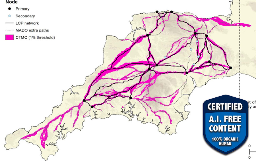
ARoman road network that spanned Devon and Cornwall and connected significant settlements with military forts across the two counties as well as wider Britannia has been discovered for the first time.
Archaeologists at the University of Exeter have used laser scans collected as part of the Environment Agency’s National LiDAR Program to identify new sections of road west of the previously understood boundary.
Using sophisticated geographical modeling techniques, which incorporate information around gradients and flood risk, the researchers have then been able to map out the full extent of the network and begin to understand the rationale for its existence.
Among the things it reveals is that far from Exeter being the main nerve center of the network, it was North Tawton that supported strategically vital connections with tidal estuaries north and south of Bodmin and Dartmoor.
These findings are explored in Remote Sensing and GIS Modelling of Roman Roads in South West Britain, which has been published in the Journal of Computer Applications in Archaeology.
The research was led by Dr Christopher Smart and Dr João Fonte, specialists in landscape archaeology and the heritage of the Roman Empire, in Exeter’s Department of Archaeology and History. Dr César Parcero Oubiña, from the Institute of Heritage Sciences, Spanish National Research Council in Spain, specialist in geospatial technologies applied to archaeology, led the modelling of the Roman roads network.
“Despite more than 70 years of scholarship, published maps of the Roman road network in southern Britain have remained largely unchanged and all are consistent in showing that west of Exeter, Roman Isca, there was little solid evidence for a system of long-distance roads,” Dr Smart said. “But the recent availability of seamless LiDAR coverage for Britain has provided the means to transform our understanding of the Roman road network that developed within the province, and nowhere more so than in the far south western counties, in the territory of the Dumnonii.”
The National LiDAR (Light Detection and Ranging) Program was conducted between 2016 and 2022 by the Environment Agency covering the whole of England, and the data was made available via the DEFRA Data Services Platform. It transformed the amount of terrain mapped of Devon and Cornwall, which had previously stood at just 11%. The Exeter team, working with public volunteers, and funded by the National Lottery Heritage Fund as part of the Digital Skills for Heritage initiative, studied the scans and together, they were able to map around 100km of additional roads.
No comments:
Post a Comment