
One thing about major active faults is that there are not too many of them. In fact they are rather uncommon and easily detected if you have your eyes open. If faults are active, the ground bends and warps forming a scarred landscape. It is easily recognized around LA or San Francisco
There are also better hidden ones out in flat country that way more tricky to spot or well eroded old ones that sometimes come back to life.
However, the majority of quakes come from the same well known faults as we have just seen in Haiti
The first problem is that people build along them. This can not be properly avoided because a decent exclusion zone would be fifty miles to either side of the fault. Yet San Francisco
Their last quake was the same magnitude as the Haitian quake and their death toll was 68. That starts been within an acceptable range for that level of disturbance.
The absolute key to it all are building codes that minimize the collapse threat. That is what has killed possibly 200,000 in Haiti
The first rule is to stop building unreinforced concrete structures at all. Even better, adopt wood frame construction for housing up to three stories. A quake will still tear them apart but they are fighting it all the way. In Kyoto
I can go further than that. I can produce stress skinned panels that have perhaps half the weight and twice the strength for about the same end cost after construction. It has not been made to happen yet, but it is feasible and is the future of global housing for that and superior energy retention and ease of construction.
Nothing is ever bullet proof but Haiti
My point remains. It is possible to build out a completely new Haiti
Fault Responsible For Haiti Quake Slices Island
by Staff Writers Washington DC
http://www.spacemart.com/reports/Fault_Responsible_For_Haiti_Quake_Slices_Island_Topography_999.html
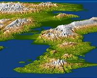
The sharp diagonal line exactly at the image center is the Enriquillo fault. Port-au-Prince
A magnitude 7.0 earthquake occurred on January 12, 2010, at
Elevation is color coded from dark green at low elevations to white at high elevations, and the topography is shaded with illumination from the left. The topography in this image is exaggerated by a factor of two.
The sharp diagonal line exactly at the image center is the Enriquillo fault. Port-au-Prince
The Enriquillo fault generally moves left-laterally (horizontally, with features across the fault shifting to the left when the fault breaks in an earthquake), but vertical movements occur along the fault where irregularities in the fault line cause local compression or extension of the earth.
Meanwhile, movements of the topography at the Earth's surface can falsely appear to be vertical where mountain slopes are cut and misaligned by horizontal shifts of the fault.
Additionally, differing erosion rates on the two sides of the fault, due to the juxtapositioning of differing rock types by the fault, can give the appearance of vertical offsets of the current topographic surface. All of these real and apparent horizontal and vertical offsets of the topographic surface may (and likely do) occur here, making the fault easily observed in the topographic data.
The elevation data used in this image were produced by the Shuttle RadarTopography Mission
For many areas of the world, SRTM data provide the first detailed three dimensional observation of landforms at regional scales.
The mission was a cooperative project between the National Aeronautics and Space Administration (NASA), the National Geospatial-Intelligence Agency (NGA) of the U.S. Pasadena , Calif. , for NASA'sScience Mission Directorate, Washington , D.C.
View Width: One degree latitude (111 kilometers, or 69 miles)
View Distance: Five degrees longitude (525 kilometers, or 325 miles)
Location: 18 to 19 degrees North latitude, 70 to 75 degrees West longitude
Orientation: View east, 5 degrees below horizontal
SRTM Data Acquired: February 2000
by Staff Writers
Woods Hole MA (SPX) Jan 21, 2010
The magnitude 7.0 earthquake that triggered disastrous destruction and mounting death tolls in Haiti this week occurred in a highly complex tangle of tectonic faults near the intersection of the Caribbean and North American crustal plates, according to a quake expert at the Woods Hole Oceanographic Institution (WHOI) who has studied faults in the region and throughout the world.
Jian Lin, a WHOI senior scientist in geology and geophysics, said that even though the quake was "large but not huge," there were three factors that made it particularly devastating: First, it was centered just 10 miles southwest of the capital city, Port au Prince; second, the quake was shallow-only about 10-15 kilometers below the land's surface; third, and more importantly, many homes and buildings in the economically poor country were not built to withstand such a force and collapsed or crumbled.
All of these circumstances made the Jan. 12 earthquake a "worst-case scenario," Lin said. Preliminary estimates of the death toll ranged from thousands to hundreds of thousands. "It should be a wake-up call for the entire Caribbean ," Lin said.
The quake struck on a 50-60-km stretch of the more than 500-km-long Enriquillo-Plantain Garden Fault, which runs generally east-west through Haiti, to the Dominican Republic to the east and Jamaica
It is a "strike-slip" fault, according to the U.S. Caribbean Plate south of the fault line was sliding east and the smaller Gonvave Platelet north of the fault was sliding west.
But most of the time, the earth's plates do not slide smoothly past one another. They stick in one spot for perhaps years or hundreds of years, until enough pressure builds along the fault and the landmasses suddenly jerk forward to relieve the pressure, releasing massive amounts of energy throughout the surrounding area. A similar, more familiar, scenario exists along California 's San Andreas Fault .
Such seismic areas "accumulate stresses all the time," says Lin, who has extensively studied a nearby, major fault , the Septentrional Fault, which runs east-west at the northern side of the Hispaniola island that makes up Haiti and Dominican Republic
Compounding the problem, he says, is that in addition to the Caribbean and North American plates, , a wide zone between the two plates is made up of a patchwork of smaller "block" plates, or "platelets"-such as the Gonvave Platelet-that make it difficult to assess the forces in the region and how they interact with one another. "If you live in adjacent areas, such as the Dominican Republic , Jamaica and Puerto Rico , you are surrounded by faults."
Residents of such areas, Lin says, should focus on ways to save their lives and the lives of their families in the event of an earthquake. "The answer lies in basic earthquake education," he says.
Those who can afford it should strengthen the construction and stability of their houses and buildings, he says. But in a place like Haiti
Some residents of earthquake zones know that after the quake's faster, but smaller, primary, or "p" wave hits, there is usually a few-second-to-one-minute wait until a larger, more powerful surface, or "s" wave strikes, Lin says. P waves come first but have smaller amplitudes and are less destructive; S waves, though slower, are larger in amplitude and, hence, more destructive.
"At least make sure you build a strong table somewhere in your house and school," said Lin. When a quake comes, "duck quickly under that table."
Lin said the Haiti
The geologist says that aftershocks, some of them significant, can be expected in the coming days, weeks, months, years, "even tens of years." But now that the stress has been relieved along that 50-60-km portion of the Enriquillo-Plantain Garden
However, the other nine-tenths of that fault and the myriad networks of faults throughout the Caribbean are, definitely, "active."
"A lot of people," Lin says, "forget [earthquakes] quickly and do not take the words of geologists seriously. But if your house is close to an active fault, it is best that you do not forget where you live."
The Woods Hole Oceanographic Institution is a private, independent organization in Falmouth , Mass.