
In the long term this will all work out. short term not so wonderful.
All of this rergion needs to be fully reforested including all the hills and up the mountains. It was originally forested and dam making merely helps control the flow as may be suitable. Rememeber all the water that falls on the basin still makes to down to the sea. Flooding those marshes takes simply better planning. The same holds true for the Nile delta.
Tree planting then supports irrigation far better. it even keeps more atmospheric water in the basin
The Demise of Mesopotamia: The Geopolitics of Water. The Desertification of Iraq
Part I
Global Research, April 08, 2022
Region: Middle East & North Africa
Theme: Environment, History
In-depth Report: IRAQ REPORT
All Global Research articles can be read in 51 languages by activating the “Translate Website” drop down menu on the top banner of our home page (Desktop version).
To receive Global Research’s Daily Newsletter (selected articles), click here.
Visit and follow us on Instagram at @globalresearch_crg and Twitter at @crglobalization. Feel free to repost and share widely Global Research articles.
***
Abstract
The decades following World War II witnessed massive investments in large dams and water reservoirs. The number of large dams increased globally from 5,000 dams in 1950 to around 50,000 in 2017, and irrigated areas doubled from 140 million hectares to 280 million hectares.
The development of public irrigation and hydropower energy, and their associated dams, was central to Cold War geopolitics and national state policies. Throughout the Cold War, water became more involved in both building up and demolishing regimes, supporting, and undermining political legitimacy, and empowering and disempowering social groups.
Today, over 263 international watercourses generate about 60% of global freshwater flow, cross the territories of 145 countries, and are home to around 40% of the world’s population. Conflicts over shared river waters cannot be interpreted without understanding the political power relations and the significance of upstream-downstream positioning of the competing or conflicting states.
For thousands of years being Mesopotamia (the land between two rivers), today’s Iraq faces water scarcity and desertification due to the continued reduction of the Tigris and Euphrates water flow into Iraqi territory. This is largely due to upstream developments on their headwaters in Turkey and Iran, and the steepening effects of climate change. In 2018, the UN Environment Program warned that Iraq was losing around 25,000 hectares of arable land.
The construction and operation of about 100 large dams and reservoirs on the Tigris and Euphrates headwaters in both Turkey and Iran in less than four decades, has drastically impaired the flow of the two rivers and caused severe land and environmental degradation including the desiccation of wetlands in Iraq.
In this article, the Tigris and Euphrates rivers mean annual flow rate records from the Ministry of Water Resources in Iraq (1960-2018) have been analyzed in correlation with dates of upstream dams filling and operation of tens of large dams in Turkey.
Conclusions indicate significant correlation that caused serious impacts including the desiccation of about 65% of the marshland’s areas in southern Iraq since the seventies to date, with continues degradation of valuable agriculture land into desertification, and other related environmental and socioeconomical aspects.
Introduction
About 96.3% of water on earth is saline. Freshwater including ice caps, lakes, rivers, groundwater, soil moisture, and atmosphere vapors covers only 2.7% of the Earth’s surface. River’s freshwater is only 0.0002 of total water on earth [.1 ]. Rivers are important natural corridors for the flows of energy, matter, and species, and are often key elements in the regulation and maintenance of landscape biodiversity [2]. With time and population explosion and drought, fresh water becomes a critical asset to meet food, water demands, development, and national security of nations.
The decades following World War II witnessed massive investments in large dams and water reservoirs. The number of large dams increased globally from 5000 in 1950 to around 50 000 in 2017. Irrigated areas also doubled from 140 million ha. to 280 million hectares. The development of public irrigation and hydro energy and associated dams was central to Cold War geopolitics as well as to wider national state policies. [3].
As a strategic asset, water is no longer linked only to environmental issues and food security issue’s but also plays a critical role in regional security arrangements. States view water as a means for political leverage and as a source of power.
There are over 263 international watercourses generating about 60% of global freshwater flow which cover almost half the earth’s land surface. They cross the territories of 145 countries and are home to around 40% of the world’s population.[4]
Shared rivers between two or more riparian states poses different levels of disputes over river water shares. Conflicts over shared rivers waters cannot be interpreted without understanding the power relations and the significance of upstream-downstream positioning of the competing or conflicting states [ 5]. In arid and semi-arid regions like the Middle East water represents a source of state power, and water scarcity is highly impacting development and national security [5].
Today Iraq faces water scarcity and desertification after continuous reduction of Tigris and Euphrates water inflows due to upstream damming of their headwaters in Turkey, Iran.
Water shortages are further aggravated by the steepening effects of climate change. The UN Environment Program reported in 2018 that Iraq is losing around 25,000 hectares of arable land annually.[6].
The construction and operation of more than 100 large dams, reservoirs, and hydroelectric power plant (HEPP) in less than four decades on Tigris and Euphrates headwaters in Turkey, Iran, has impaired the flow of the two rivers and caused sever land and environmental degradation in Iraq.
Since the 1970s, Turkey has pursued an ambitious Southeastern Anatolia Project (GAP), or “Guneydogu Anadolu Projesi” (Turkish). The project involves the construction of 90 dams, and 60 hydro-electrical power stations [7 ], water diversion tunnels, and irrigation infrastructure on Tigris and Euphrates headwaters, with storage capacity exceeding 114 BCM. Full implementation of (GAP) facilities will harness nearly 70-80 percent of the Euphrates River water flow into Iraq and Syria [8].
Throughout the Cold War, water has become more involved in both building and demolishing regimes, supporting, and undermining political legitimacy, and empowering and disempowering social groups [9].
This paper presents an overview of how Cold War politics after World War II evolved to create tensions and potential conflicting situations between riparian countries within the Tigris and Euphrates basins.
As a NATO active member, Turkey received political, financial, and technical support to accelerate the construction of GAP mega dams without negotiating protocols with downstream riparian countries or conducting comprehensive environmental impact assessments to define the effects of these dams on them, as required by international water laws [10].
Tigris and Euphrates rivers mean annual flow rate (MAFR) records from the ministry of water resources in Iraq (MoWRI), Appendix A, table I, [14] [16], have been analyzed in correlation with dates of upstream dams filling and operation in Turkey and Iran, to identify the real impacts of these developments on the acceleration of the desiccation of the marshlands southern Iraq through the nineties to date.
With partial implementation of the GAP project, Iraq is already going through significant water scarcity, desertification [6], and the desiccation of about 65% of major areas of the marshlands after the diminishing of flood waves, major water recharge of these wetlands [11]. It’s been predicted that both Tigris and Euphrates rivers in Iraq might diminish by the year of 2040’s [12].
Water resources status of Iraq
Before the 1970s the flow of the Tigris and Euphrates rivers in Iraq were considered semi-natural [8]]. Both rivers are international rivers shared mainly by four countries (Turkey, Syria, Iraq, and Iran). Most headwaters of both rivers are in Turkey and Iran’s highlands. Tables 1 and 2 pertain to the major hydrological parameters of both Tigris and Euphrates drainage basins.
Since about 79% of water resources of the two rivers in Iraq originate mainly from Turkey and Iran’s highlands [8], a significant decline in total annual inflow of Euphrates in Iraq started in the mid-1970s, right after the construction and the operation of the Keban dam in Turkey and Tabqa dam in Syria.
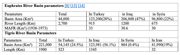
Table 1: Main Hydrological parameters of Tigris and Euphrates rivers in Iraq.
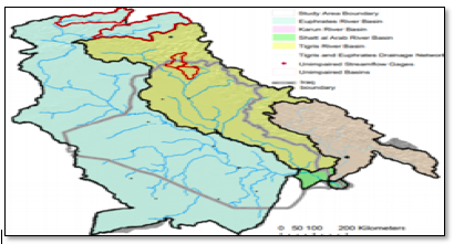
Figure 1: Tigris and Euphrates River basins across riparian states [15].
Early 1980s to the present the total annual water inflow of both Tigris and Euphrates in Iraq have been going through continuous decline (figure 2), due mainly to the construction of the Southeast Anatolia Project, and other water developments in Iran, Syria, and Iraq.
The first stage of GAP project includes the building of 22 mega and large dams and 19 hydropower plants with storage capacity of (>114 BCM) on the Euphrates and Tigris (Table 3), which exceeds the natural annual flow volume of the two rivers [8].
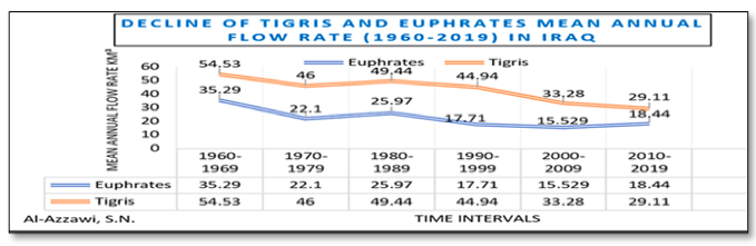
Figure 2: Decline of mean annual flow of both Tigris and Euphrates water last five decades. Source of data MoWRI in references [14][16].
Another important source of surface water in Iraq is Shatt al Arab River. This river forms from the confluence of the Euphrates and Tigris Rivers near the city of Qurna in southern Iraq, figure 3 . Downstream of Qurna city to the Arabian Gulf, the length of the river is 192 Km [17]. The area draining to the Shatt al Arab river is shared between Iran and Iraq. In addition to the Euphrates and Tigris Rivers, the Karkheh and the Karun tributaries originate from the Zagros highlands in Iran contribute water to Shatt al Arab main channel in Iraq [8].
Mean annual inflow of Shatt Al Arab during (1947-1960) from Tigris and Euphrates was about 23 BCM in Maqal (Makal) district close to Basra city center (figure 3 )[18], increases to about 37.5 BCM further south after Karun tributary discharges about 14.4 BCM of its water into the river [18].
Last two decades, the contribution of Tigris, Euphrates, and Karun rivers inflow into Shatt Al Arab have been gradually declining. The flow rate of the river dropped to historical level of 45 CMS (Cubic Meter Per Second) reported in (2011), compared to 919 cms in (1977-1978) [19]. Shatt Al Arab annual flow rate decline is also related to the construction of large dams and reservoirs upstream in Turkey and Iran on both Tigris and Euphrates headwaters [8] figure 4.
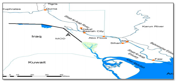
Figure 3: Shatt Al Arab River through Basra city [17]
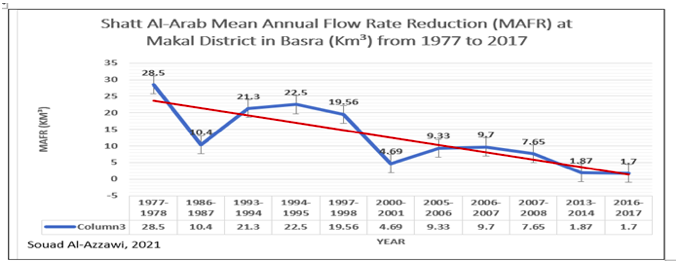
Figure 4: Shatt Al-Arab mean annual flow rate at Makal district in Basra.[18]
Iran on other hand constructed 37 dams on Tigris tributaries, Karun, and Karkha rivers originating from the Zagros and Touros highlands in Iran since the seventies [20] [21].
Syria also constructed three large dams on Euphrates since mid-seventies [8]. Iraq built 5 large dams at same period [8] , in addition to the construction of 17 dams last decade on Tigris tributaries within Kurdistan Region of Iraq ( KRI) last decade, with 24 more dams under construction currently [22 ]. Mean annual water inflow of both Tigris and Euphrates in Iraq during the sixties was around 83 BCM, figure 2. In four decades, mean water inflow dropped to 47 BCM. With climate changes, and full implementation of GAP project, further reduction is expected to the depletion of both rivers in Iraq around 2040’s according to (UN-IAU Interagency information and analysis unit) (Report, 2010 [12].
The Southeastern Anatolia Development Project
The Southeastern Anatolia Development (GAP) is part of a more comprehensive project intends to build 1,783 dams and hydro-electric power plants (HEPP) in Turkey by 2023 in addition to over 2,000 existing ones, which will affect millions of people [23] inside Turkey, and more than 30 million people downstream in Syria and Iraq.
The following section is a general historical review of the politics accelerated the development of the GAP project last four decades, starting from the construction of Keban dam, first mega dam constructed on Euphrates River headwaters in Turkey.
1. Keban dam
In 1962 the Turkish parliament allocated funds for a feasibility study for the construction of a dam at Keban city on the headwaters of the Euphrates River. That same year, a contract was signed with EBASCO Services Inc., an American engineering firm founded by the General Electric Company in 1905 [24].
The project Feasibility report released in October 1963.” EBASCO recommended the construction of the dam at Keban in a 350-page “economic feasibility” report. The project technical document supposed to come with technical details about the proposed design and the cost of the dam, but, the report was more as a political document [24]. It was an analysis of the whole Turkish economy and society. It offered a technocratic vision for the country’s future rather than the project region only. The study was produced as a prospectus for international capital, it was less about the development of Eastern and Southeastern Anatolia and more about the social and economic development of Turkey’s largest cities in the west [24].
In 1965, Turkey began construction of the Keban dam. Ankara obtained funding for the dam from the United States and several West European countries led by West Germany and the contracted consortium of West European companies to complete the dam.
The total aid for the project totaled some $135 million US Dollars [24]. Keban and Al-Tabqa dam in Syria were both completed and started filling the reservoirs (1973-1974) [25]. Filling the (31 BCM) storage capacity reservoirs of Keban and Tabqa dam reservoir (11.6BCM) during (1973,1974, 1975) caused significant decline of (MAFR) of Euphrates river in Iraq to (15.31, 9.02, 9.42 BCM)( MoWRI in Table I, Appendix A). Comparing these records to Euphrates average annual flow rate (1930-1970) of 30 BCM (Appendix A, Table I) before the construction of Keban and Tabqa dams. This decline caused serious damages to downstream riparian countries (Syria and Iraq) at the time, but the damages in Iraq were more severe.
Permanent Impacts of operating Keban dam is about 25% reduction of the annual inflow rate of the Euphrates in Iraq [26]. This reduction and control of the river flow ended most of the spring season flood waves [8].
Amidist most critical conflicts of the Cold War, right after filling of Keban dam, with the world’s oil crises early seventies of last century, the nationalization of Iraqi oil in 1973 [27], EBASCO report recommendation for Turkey’s economic development , and total political, technical, and financial support of the NATO countries during the construction of Keban dam, all opened the door widely for Turkey to further extend the development of Southeastern Anatolia region through what today called the Southeastern Anatolia project (GAP).
2. Southeastern Anatolia Project (GAP) was launched in 1977 and introduced by Turkey’s State hydraulic works (DSİ) through bringing together various programs on the Tigris and Euphrates rivers, creating a regional project that covers nine provinces of an area about 74,000 km² [28]. The completed project aims to have built a total of 90 dams and 60 hydroelectric power plants, generating 27 billion kilowatt hours of electricity and irrigate 1.7 million hectares of surface area to grow cash crops and promote agro-industries such as food processing for export [28].
Phase one of the Southeastern Anatolia project include the construction of twenty-two large and mega dams, nineteen hydraulic power plants, and huge water conversion tunnels, figure 5 shows the locations of main GAP dams [29]. Without environmental impact assessment, planning, design, and construction of the project were singly decided by Turkey without negotiations with other downstream riparian states (Syria and Iraq) [10] as required by 1997 United Nations Convention on the Law of Non-navigational Uses of International Watercourses, and other related water laws [30].
Turkey’s stand on this issue is based on the principle of the Harmon Doctrine, whereby the upstream riparian country owns the water and controls its distribution, [31]. The problem with the Harmon Doctrine, “not only do the vast number of water treaties bear witness against this Doctrine, but all the international and federal judicial tribunals that have experience with international water problems have rejected it; all the learned associations, institutes, and other bodies which have studied these problems have rejected it in their statements of principles”, [32, page 142].
The International water law (IWL) as a process dismantled absolute sovereignty theories Including: Absolute territorial sovereignty theory; Absolute territorial integrity theory. As McCarthy, 1996, stated “The Harmon Doctrine … buried, not praised”)[32].
The three foundation pillars of IWL:
The equitable and reasonable utilization principle;
The no-harm rule; and
The principle of co-operation [32 ].
Hence the GAP project stands against all these principals in every single step of its planning, design, construction, and operation.
While the decision to build a dam is often seen as a sovereign decision, the decision of external agencies to support a dam depends on whether the proposed project complies with that agency’s policies and guidelines”. Such policies, argues by the world commission on dams (WCD), “should incorporate aspects of notification to riparian States, the desirability of ‘consent’ or ‘no objection’ from riparian States and independent expert assessment of social, ecological, and heritage and cultural impacts on downstream riparian states[10].
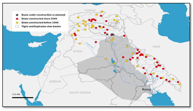
Figure 5: Major GAP constructed dams and their distribution along Tigris and Euphrates headwater in Turkey [29].
The world commission on dams (WCD) Policy Principle 7.5, Strategic Priority 7, states: “Where a government agency plans or facilitates the construction of a dam on a shared river in contravention of the principle of good faith negotiations between riparian’s’. [10].
The World Bank and the International Monetary Fund refused to fund any part of the GAP after funding the construction of the Karakaya Dam (1983-1988) due to concerns over social and environmental impacts, as well as protests from governments in Iraq and Syria [10].
During the eighties, Initial Goals of GAP projects were mainly limited to developing irrigation and industrial zones. In 1989, Turkish state officially established the Southeast Anatolia Regional Development Administration.
The law governing the Administration demonstrated how the Turkish government saw this project as involving more than simply economic development. The GAP scheme engaged the entire landscape of Southeast Anatolia, including political, social, cultural, and environmental spheres.
Law decree 388 (1989) defined the Administration’s duties. GAP Regional Development Administration published the goals of the project as: 1. generation of hydroelectric power; 2. development of regional agriculture through irrigation. 3. development of a regional agro-industrial base; and 4. formulation of a mid- to long-term solution to Kurdish ethnic separatism [24] [ stahle page 228].
To Europe and America, the GAP mega dams project was not about safeguarding foreign policy interests, such as containment of the Soviet Union and the extension of communist ideology in the middle east only, rather, the dams were a key component in producing a particular economic order, and opening overseas markets to exports, maintaining a specific technical and industrial base in the donor country (like Turkey) [24].
In a report titled “THE EUPHRATES TRIANGLE, Security Implications of the Southeastern Anatolia Project” of the U.S. National Defense University ,1999 [31], statements clearly defined the U.S.-NATO stance on the construction of GAP project, such us;
“A secure and stable Turkey is in the U.S. national interest. Turkey is the southern bastion of NATO, and it borders on three states that may pose a threat to the United States–Iraq, Syria, and Iran.”
Also, that;
“the NATO southern flank, with Turkey in particular, still faced severe regional instability. For this reason, SACEUR designated southeastern Turkey as one of several areas within Allied Command Europe that would continue to receive priority military planning efforts.”
In the recommendation section of the same report:
” U.S. policy in the region has been to maintain close ties to Turkey, shaping the environment with international assistance, arms control, nonproliferation initiatives, and isolation of rogue states that support terrorism or violate international law.”
These states were previously identified in the same article as( Syria, Iraq, and Iran) [31].
Water in such context should not be considered as a source of conflict only, but as a mean that can be used during the conflict. Turkey have been using water to serve political aims, causing significant threat to riparian countries and the population’s human security [9] (Laura Meijer).
To the US and NATO powers, supporting the construction of GAP projects politically and financially with their negative impacts on Turkey’s downstream riparian countries (Syria, Iraq,) was more of goal and political strategy to isolate and end their social regimes. Even if that support means the destruction of river’s basins ecological, cultural, and socioeconomical systems.
As Kibaroglu, 2014 stated;
“While the Cold War deepened the tensions over water, Turkey joined NATO whilst Syria and Iraq kept close ties with the USSR” [33]. Other political issues are related to the Kurdistan Workers Party (PKK), and the territorial dispute between Turkey and Syria over the Hatay province which was a major source of tension between the two countries until 2005.” [34].
Reconstruction of the project never stopped, with no environmental or social impact assessments at local or regional levels [10].
Environmental Impact assessments are an international requirement for such strategic projects. They are usually conducted to define the impacts of the (dams in this case) on the whole river basin including hydrological, geomorphological, ecological, connected wetlands, and socioeconomic status of all cities downstream in riparian countries and the suggested alternatives to eliminate these impacts.
To earn back international funds after the controversial (Ataturk) dam had been built and start filling the reservoir in 1990, the Turkish government further developed the project into a new international interest called “sustainable human development”.
The original design was expanded to include schools, roads, health care centers, housing, women’s projects, and tourism. This way the project earned back the international funding including the World Bank, Food and Agriculture Organization (FAO), United Nations Development (UNDP) ,table 3 shows the countries and organizations financially supported GAP project.
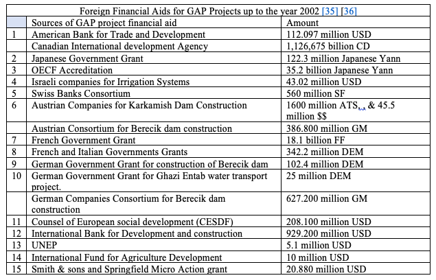
Table 3: Foreign Countries and organizations financially supported the GAP projects till 2002 [35 ][36].
Entities of the United Nations supported and funded parts the project, table 3, knowing that sustainability of a river basin including human development is determined by whether the river system can support the long-term ecological and socioeconomic functions of the river basin as a whole [37], and not only part of the basin within the Turkish territories.
No detailed technical reports from these organizations or Turkey exploring the impacts of GAP mega dams on whole rivers basin including ecological and socioeconomic impacts on downstream riparian countries before constructing them [10].
UNEP and other UN organizations dealt with what they called (drying marshlands issue for security reasons) in southern Iraq with many studies during the 1990s. Most of these studies were local, not regional to cover the impacts of constructing all these dams and hydropower stations on the whole Tigris and Euphrates basins including wetlands.
Other related research conclusions built on processing enhanced Landsat and other remote sensing images without enough ground truth data and rate of flow records.
The GAP project created international conflicts regarding water sharing and escalated tensions among Turkey, Syria and Iraq as the three riparian states of the Euphrates and Tigris basins.
Turkey has for a long time rejected the notion of sharing rivers in an equitable and fair manner as stipulated by international law. It was one out of three countries voting against the 1997 UN Convention on the Law of the Non-navigational Uses of International Watercourses which establishes the principles of equitable and reasonable utilization, of not doing harm, of cooperation between riparian countries, and of notification and consultation [38].
According to international law experts, these principles form part of the customary law also binding those countries that have not ratified the relevant conventions. The obligation to inform and consult with riparian countries at an early stage and to conclude an agreement before a project is realized is also part of the World Bank Safeguard Policies [23].
Impacts of GAP Projects on the Desiccation of Wetland in Southern Iraq
[Desiccation is defined as the “Removal of Moisture”]
Marshlands are mainly located in southern Iraq and are directly connected to the Tigris and Euphrates rivers, figure 6 [39]. They are in Nasiriya, Basra, Diwaniya, and Umara governorates.
Before the intensive construction of dams on the Tigris and Euphrates rivers headwaters in Turkey highlands early seventies of last century, area of the marshes (Ahwar) was highly variable annually and seasonally, ranged from (8000-20000 Km²) [40]. In summer (June-October) and dry years, the area become only 25% of the area in flood season (3500 Km²) [41] due to decline of the two rivers MAFR and high evaporation rate. Many marshes in the area are seasonal and disappear in summer. Others are permeant like the following:
The Euphrates river Marshes: including Al Hammar permanent largest marsh with many other small seasonal marshes. In flooding season, they were all look connected, and are recharged mainly from Euphrates River and flowing water from central marsh westward in dry season. Al Hammar marsh area range between (1250-2500) Km² [40]. The American company T.A.M.S.(Tippet-Abbott-McCarthy, Stratton) estimated area of Al Hammar in 1954 about (1250) Km² [40].
The central marshlands: located between Tigris and Euphrates rivers including Abi Zarak and Chibayeesh marshes. Extending from Shaikh Saad city in Missan to Qurna in Basra, with an area of 4000 Km² in flood season to less than 1920 Km² in dry season, recharged from west Tigris and east Euphrates distributaries [41].
Hawaiza marsh extends from Iranian to Iraqi territories. Area of Hawaiza inside Iraq is about (2500-3000 Km²) in flooding time, to about (950 Km²) in summer, and (650 Km²) in dry years[19]. Inside Iran the extension of Hawaiza is called (Hoor Alazim) , with an area of ( 1250 Km²) in flood season [42 ]. Major recharge of Huwaiza in Iran was from Karkha river until 1998, before operating Karkha2 dam with an annual flow of 3.2BCM [42 ]. From Iraqi side recharge of Hawaiza is from Tigris River distributaries during flood seasons [40].
1. Impacts of GAP Development on the Desiccation of Marshlands in Iraq:
Streams and rivers are hydrologically connected to downstream water features like wetlands and floodplains via channels that convey surface and subsurface water either year-round in perennial flow or seasonally [43]. Water structures like dams on any river affect the frequency, duration, magnitude, timing, and rate of change of connections between headwater streams, and downstream water.
They cause fragmentation of longitudinal connections between headwater streams and downstream waters, including the deltaic wetlands. The impacts of changing streamflow are numerous, including altered flow regime, stream geomorphology, habitat, and ecology [43]. Wetlands in southern Iraq have been subjected to serious stresses after the building of tens of dams on both Tigris and Euphrates within three decades. These dams altered their hydrological, ecological, geomorphological, socioeconomical, and environmental systems due to the elimination of seasonal flood waves major water recharge of the marshlands, and the significant decline of Tigris and Euphrates mean annual flow rate (MAFR). This alteration was more profound after the construction and operation of the GAPS dams in Turkey since the seventies of last century to date [44].
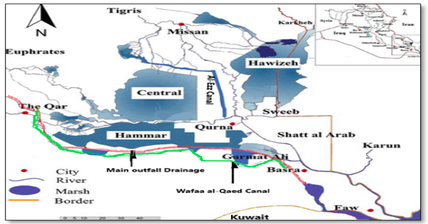
Figure 6: Marshlands and diversion canals in southern Iraq, modified after (Abdullah, A. 2016)[39].
One of the important impacts of this flow impairments is the desiccation of marshlands in southern Iraq [26]. Acceleration of this desiccation occurred during the nineties, when Turkey filled and operated 22 dams and hydroelectrical power stations on Tigris and Euphrates rivers headwaters in one decade only, (Appendix B, table II) [45].
As a result the MAFR of both rivers dropped drastically (Appendix A), figure 2. At that time, Iraq was under the economic sanctions, facing severe shortages of food and necessary chemicals for water purification plants, Iraq considered Turkey’s action (being a NATO member) as an assault to deprive Iraqi population access to fresh water for domestic and agriculture uses [10]. Such an action would raise the already high economic sanctions human casualties to a genocide level [46]. As a result, mid-nineties the Iraqi government constructed four freshwater diversion canals through the marshlands to supply potable water for Nasiriya and Basra cities population. These canals caused further dissection of the marshlands as will be explained later in this article.
In the next section the Tigris and Euphrates rivers mean annual flow rate (MAFR) records from the ministry of water resources in Iraq (MoWRI), Appendix A, table I, [14] [16], have been analyzed in correlation with dates of upstream dams filling and operation in Turkey and Iran, to figure out the real impacts of upstream developments on the acceleration of the desiccation of the marshlands through the nineties to date.
2. Desiccation of Hammar and Central Marshlands during the nineties of last century: Early seventies to 2002, Turkey constructed, and operated 32 dams and hydroelectrical power stations on Tigris and Euphrates headwaters with total storage capacity of (99.520 BCM) [45]. Twenty-two of these developments including Ataturk mega dam, with collective storage capacity of (56.969BCM) started filling and operating during the nineties of last century, Appendix B [45]. Thirteen of them with storage capacity (51.664 BCM) were filled and operated on Euphrates River, the other 9 with storage capacity of (4.55BCM) were on Tigris River, Appendix B, table II.
Hammar and Central marshlands are mainly connected and recharge from the Euphrates River and some of Tigris distributaries in case of central marshes [40] . To maintain an area of about 7000 Km² as before the construction of GAP projects, about (14-15 BCM) of water inflow is needed annually to recharge them from Euphrates River in Nasiriya city, the entrance to these marshes [11] [41] [47]. This amount historically was available from seasonal (March-May) flood waves of the river [47], figure 7.
These flood waves disappeared after controlling river flow by the dams on headwaters [11]. The relatively high flow water release from dams on headwaters in Turkey shifted from spring to summer season (June – September) to meet peak electricity demands [11]. Highest evaporation rate in Iraq is during summer [41].
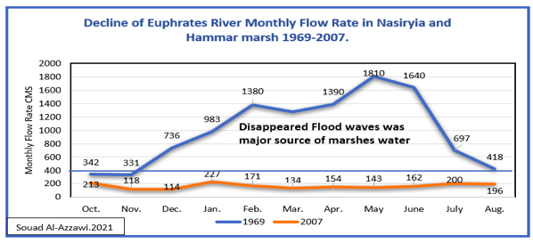
Figure 7: Elimination of spring high flow (flood waves) of Euphrates River in Nasiriya City the entrance to Marshlands. (Flow records from ref. 11).
Mean Annual Flow of Euphrates measured in Husaiba station on Syrian/Iraqi borders before building the dams (1930-1973) is about 30 BCM [14]. During the filling and operating of Ataturk dam (1990, 1991, 1992, 1993, 1994), and six other smaller dams on Euphrates, Appendix B, table II. The reservoir level of Ataturk dam reached 535m a.s.l in March 1994 [48]. Mean annual flow of Euphrates River at Husaiba city on the Syrian/Iraqi borders during these years were (8.9, 12.4, 12.15, 12.37, and 15.29 BCM) [MoWRI), Appendix A, table I [14], figure 8.
It is well documented that until the seventies, the Euphrates river was losing about 50% of its mean annual flow rate or about (14-15) BCM of between Heet city close to Syrian/ Iraqi borders to Nasiriya city (Entrance to Marshlands) [40], mainly to meet domestic and agricultural demands for all cities along Euphrates river banks [11].
The Euphrates annual flow rate less than 15 BCM on Iraq/Syrian borders means that there is not enough water to recharge the Hammar and Central Marshlands in southern Iraq for five years (1990-1994), figure 8.
The situation further deteriorated with an annual evaporation rate of 2895 mm/year in Nasiriya [49], which means annual water losses of about (8.26 BCM) from both marshlands water surfaces.
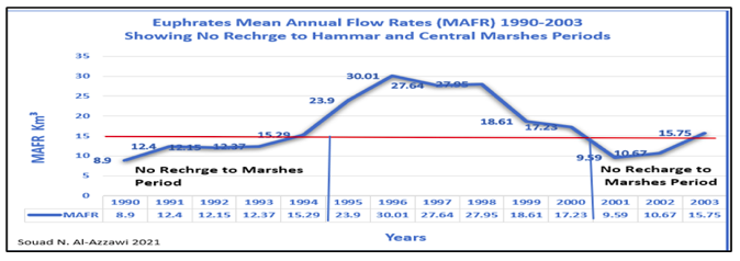
Figure 8: Euphrates River mean annual flow rate in Iraq (1990-2003), showing periods of no recharge to Hammar and Central marshlands during the nineties (Water records, Appendix A)
Estimations of changes of Hammar and Central marshlands areas through the period (1973-2018) are shown in Figure 9 .
Data of the graph are taken from remote sensing interpretations in published articles and reports listed in table 4. From the graph we notice that from 1973-1990, Hammar and Central marshlands lost about 2000 Km² of its area, after the construction and operation of (Keban, 1973; Karakaya, 1986; Hancagiz, 1988; Hecihider,1989) on the Euphrates headwaters in Turkey (table); Qadisya dam in Iraq, 1986; Tabqa dam,1973 and Baath dam,1988 in Syria[8][45].
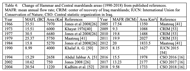
From table II, Appendix B, between 1998- 2002, other seven GAP dams and hydro electrical power stations on Euphrates River headwaters were filled and operated (Kahta, Camgazi, Gayt, Ozluc, Karkamis, and Berecik)[45 ] , with operating Tishreen dam in Syria 1999, figure 8. Euphrates MAFR measured on Iraqi/Syrian borders during the years of (1998, 1999, 2000, 2001, 2002) were (27.9, 18.61. 17.23, 9.59, 10.67 BCM) consecutively (Appendix A, table I). For the reason mentioned previously, throughout this period and from figure 9, Hammar and Central marshlands lost an extra 600 Km² from its area and ends up to about 750 Km² in 2002 [26].Mid-nineties the Iraqi government constructed and operated four freshwater diversion canals (al EZZ, Taj al Marek, Wafaa al Qaed, and Um al Marek canals) within the marshlands area. Most of these canals started operating from 1994-1998 [55]. The construction of these fresh water diversion canals caused further 1300 Km² reduction of the area of Hammar and Central marshlands, figure 9, as explained in the next section.
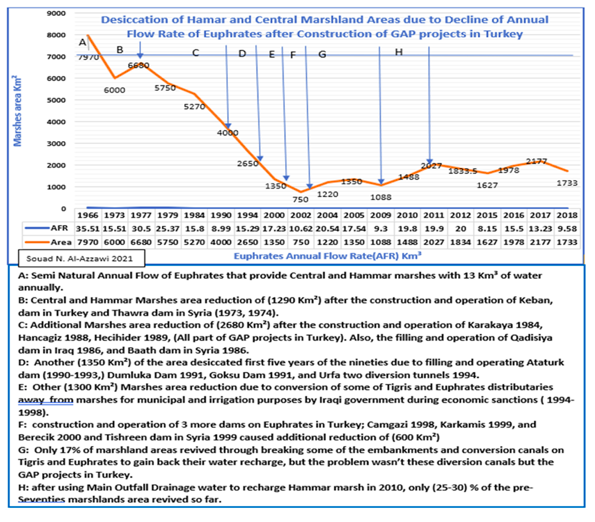
Figure 9: Desiccation of Hammar and Central marshes due to continues decline of Euphrates and Tigris annual flow rate after the construction and operation of GAP dams.
3. Desiccation of Hawaiza marsh: this marsh is located east of Amara city southern Iraq on Tigris River. It extends from Iranian territories (called Howr Al-Zim) to Iraqi territories [42]. During the seventies extension of this marsh in Iraq was about (2435Km²) in flood seasons [Nomas, 19 ] and about 950 Km² in summer and 650 Km² in dry years [Nomas, 19], in Iran its area was about (641-1250 Km² ), figure 3 , but both parts are one hydrological and ecological unit [40].
Until 1998 the Karkha river was the major source of water that recharged the Hawaiza marsh from the Iranian side. From the Iraqi side the marsh is recharged by Tigris distributaries Kahala, Musharah, and Majaria canals mainly during floods time [21].
Hawaiza marsh was also affected by the construction and operation of 9 dams and hydroelectrical power stations with total storage capacity of (6.383 BCM) on Tigris river headwaters in Turkey during the nineties, Appendix B, table II. Five of them were filled and operated from (1997-2000) [45 ]. Iraq filled and operated the Udhaim dam (1.5 BCM) in 1999[9]. Iran filled and operated two dams, one of them is the Karkha2 dam in 1998, with storage capacity (5.6 BCM) [56].
Tigris river MAFR measured in Kut city (180 Km) south of Baghdad, during the period of (1998, 1999, 2000, 2001), were ( 39.85, 18.88, 18.85, 21.13 BCM) Appendix A, table I. Historical mean annual flow rate of Tigris in Kut city from records of the Ministry of Water Resources in Iraq for the period (1933-1973) is about (49.20 BCM) Appendix A. During the seventies, more than 10 BCM out of the 49 BCM was recharging Hawaiza and central marshes during flood season [57].
Karkha2 dam in Iran was constructed during (1992-1998) on Karkha river, a tributary of Tigris River originates from west Iranian highlands and ends up in Hawaiza marsh in Iran ( Al Azim marsh), figure. The dam reservoir capacity is 5.9 BCM [42].
Starting from 1998-2000, filling then operating the dam from Karkha river cut off an annual recharge to Al Azim /Hawaiza marsh [42]. Mohsen Saeedi et al, in a published an article [42 ] wrote; “Hoor-Al-Azim/Al-Havizeh reached its minimum surface area at year 2000 and lost ~84% of its area following the exploitation of Karkheh dam in 1998”. He proceeded that “ by disturbing the water inflow to the Hoor-Al-Azim, Karkheh dam exploitation is the main parameter which caused surface area reduction in Al-Azim/Al-Havizeh wetland[58 ]”.
From 2000 to 2014 a sign of revival is observable over the wetland area so that its area augmented to 1714 km2, but still the total loss of wetland is ~55% from 1973 to 2017[42]. Hawaiza marsh lost about 2000 Km² from its area within Iraqi territories mainly due to dams filling and operations all during the nineties.
4. Impacts of constructing freshwater diversion canals southern Iraq (1994 -1998) on further desiccation of marshlands
After the military operations of Gulf war 1, 1991, with the intended destruction of the public services and the civil infrastructure by American coalition including electricity, water supply and wastewater treatment plants, Irrigation and drainage pumping stations, bridges, food storages [59] [60].
Economic Sanctions imposed on Iraq prevented repairing all the destroyed infrastructure specifically those required spare parts like pumps and chemical reagents, including electricity installations, water purification and sewage treatment plants, and water networks [59]. Harvard Study Team in their visit to Iraq observed that; “people collecting water from broken pipes surrounded by pools of murky water or even directly from drainage ditches”[60]. Loss of electricity had also caused Baghdad’s two sewage treatment plants to stop working and spilling raw sewage into the Tigris River. In neighborhoods in both Basra and Baghdad, whole streets were blocked by pools of foul-smelling water [60] [Starving Iraq].
Without public potable water supply, people had to use raw water directly from rivers for a while. About (50000) mostly under five children died in 1991 only [60]. The impacts of economic sanctions were severe specifically among population in south of Iraq [60]. Because of lack of clean water, food, and medicine, WHO supported data indicated that “Mortality in under-fives had risen 600% between 1990 -94, while there has been a 500% rise in low-birth-weight infants, and a doubling of the infant mortality rate of Baghdad over the same period”. Former UN official Denis Halliday resigned his job in Iraq because he considered sanctions against Iraq amount to ‘genocide’ [46].
During this period only about 40% of Euphrates River MAFR entered the Iraqi territories because of the filling and operation of Ataturk and eleven other dams in Turkey, Appendix B, table II. The release of sewage water discharges to the river caused further deterioration of water quality. Large areas of marshlands connected to Euphrates River were desiccated due to decline in MAFR with serious deterioration of their water quality, figure 10. In 1994, Al-Imara and Jawad from Marin science Centre in Basra University published a paper presents the results of Physio-chemical properties of water sampling program conducted in December of 1991 [61] (during the filling of Ataturk dam [62]. The sampling program were conducted before the construction of any freshwater conversion canals through the marshlands by the Iraqi state companies, and covered water courses from Qurna to Arabian Gulf [61]. Measured salinity of Euphrates water samples at Qurna before confluence with Tigris River and after flowing through marshlands was (5280) part per million (ppm). According to WHO water quality standards, this salinity value is not suitable for human use [63], also not acceptable for agriculture, animal, or industrial uses. Salinity values from Tigris- Swaib canal (after exiting Huwaiza marsh) was 5020 ppm; Hartha, 6200 ppm; Garmat Ali, 6500 ppm; Basra, 6370 ppm [61 ]. Al these and other water parameters values give clear indication of what southern Iraqi cities were going through with the continues deterioration of surface water quality to meet population water demands through the economic sanctions.
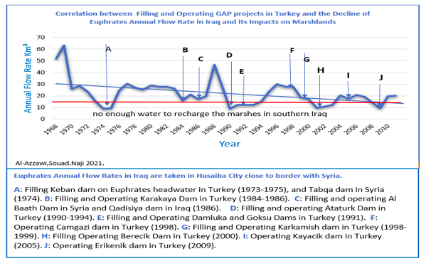
Figure 10: Correlation of filling and operating GAP project dams on decline of Euphrates River MAFR and the dissection of marshlands southern Iraq. [ 45].
To prevent further casualties because of the inability to purify and supply clean water, four artificial water diversion canals were constructed by Iraqi state companies and operated from (1994-1998) [55]. The canals were designed to prevent mixing of what remained of Tigris and Euphrates fresh water with polluted and saline marshlands water, and to convert some of Tigris flood water to Euphrates River south Basra city to supply potable and irrigation water to highly populated villages and cities of Nasiriya, Shatra, and Basra. These projects are:
Al- Ezz river: Recommended by American’s consultants (Tippets Abbott McCarthy Stratton),1958 [64]. This artificial canal was constructed mid-1993 and operation started 1994-1995 [65]. Its an open channel designed to transfer fresh water from Beterra’a and Great Majar distributaries of Tigris river south western Omara city to Euphrates river main channel south of Qurna city with mean flow rate of 256 cms [65] ,figure 3 . Main function of the project was to prevents mixing of Tigris distributaries fresh water with saline water of the central marshlands, and to transfer more fresh water to Euphrates River south of Nasiriya city to meet water demands of tens of populated Basra villages after four years of drastic decline.
Wafaa Al Qaed Canal: after the American occupation of Iraq in 2003, the under occupation assigned government changed the name of this canal to (al Bada’a Canal), figure 5. An Italian company designed this canal during the eighties [66], and the construction were executed by state Iraqi companies and took three years during economic sanctions. The canal operated in 1997 [64]. The length of this open channel is 238.5 Km, built to transfer (21 cms) fresh water from Tigris (Gharaf) distributary to Nasiriya and south of Basra cities [66].
This canal is still supplying fresh water to the cities of Nasiriya, Shatra, and Basra till this day. Practically it is the only source of fresh water currently in Basra after the shutdown of ten water purification plants on Shatt Al Arab waterway due to sea water intrusion last decade [67].
After all criticism and accusations of the American’s propaganda during the economic sanctions that these canals are constructed to dry up the marshlands for security reasons, the occupation assigned Iraqi government after 2003 had to keep these canals to supply fresh water to about 2.5 million of Basra and Nasiriya population [67][68]. For Eighteen years the authorities couldn’t solve the problem of supplying potable water to villages of Nasiriya and Basra residents other than this canal. In 2018, about 118000 of Basra residents were hospitalized from drinking polluted water supplied from Shatt Al Arab water purification plants [68]. The minister of water resources in July 16, 2020 [69] announced that PM council approved turning al Bada’a (Wafaa Al Qaed) open canal into more efficient closed conduit canal for water supply! One should ask; Why keep this canal if it was constructed to dry up the marshlands???
Taj Al Marek Canal (Saad Canal): is an open channel constructed in 1993 and start operating in 1994 after closing Musandeck Weir which converts water to central marshlands [ 70]. Located east of Tigris River, about 5 Km away from Omara city. The canal length is (36.5 Km), transfer 400 cms of Tigris flood water to Sanaf marsh which is connected to Huwaiza marsh [70]. From south Hawaiza marsh water flows to Shatt Al Arab through two small canals (Swaib and Kasara) [40].
Um Al Marek Canal: constructed in 1994, west of Euphrates 10 Km from Nasiriya city [70]. The canal is 108 Km length, built to transfer what remained of Euphrates fresh water to supply potable and irrigation water to all villages along the way to Rumaila city east of Basra [70].
It’s worth mentioning that all these diversion canals except the Ezz canal, are still operating currently because there are no other alternatives to supply fresh water for tens of populated villages of Basra, Omara, and Nasiriya cities.
The construction and operation of these four canals also caused further desiccation of about 1300 Km³ of central marshlands between 1994-1998, table 5, figure 9.
From previous data we conclude that about 4200 Km² of the marshlands southern Iraq desiccated due to the decline of the mean annual flow of Euphrates and Tigris after the construction and operation of more than 31 of GAP dams and HEPP from 1973-2002. The construction of four freshwater diversion canals through the marshlands in Iraq caused further desiccation of about 1300 Km² during the nineties of last century. Also, the filling operating of Karkha dam in Iran caused the desiccation of about (1500 Km²) of Hawaiza marshland between 1998-2001. Total desiccated marshland areas by end of Nineties were (7000 Km²) out of original area 8350 [ 16] Km². Remaining of the marshland area was (1350 Km²). After 2003, elimination of Ezz canal passing through central marshlands recovered only about 1000 Km². Studying all scenarios of recovery and flooding last two decades, still the current area of the marshlands is only (2500 -3000 Km²), figure 11 , simply because there is no enough water to revive them.
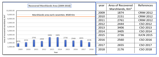
Figure 11: Recovered marshlands areas from 2009-2018.
5. Construction of the Third River in Iraq: The Main Outfall Drain (MOD) is considered one of the largest water development projects in Iraq. Its an open channel extends 565 Km between Tigris and Euphrates rivers from north of Baghdad to Shatt Al Basra canal west of Basra city [FAO 2008[47]. From Shatt Al Basra canal, through Khour al Zubair estuary the MOD water final destiny is discharged to the Arabian Gulf (figure 5 ). The MOD main functions is to collect drainage water from irrigated agricultural lands between Tigris and Euphrates Rivers to minimize water logging and soil salinity, and to protect water quality of the two rivers through receiving polluted agriculture and municipalities waste water effluents of all cities along the project (Baghdad, Al Anbar, Wasit, Diwaniya, Hella, Karbala, Najaf, Nasiriya, and Basra) [71] .It’s also designed to act as a barrier against the expansion of sand dunes towards cities and irrigated land. Southern part of the project designed to serve as a navigation waterway for inland transportation to the Arabian Gulf [71] Figure (5). Kolars, 1994 wrote about MOD “This Impressive canal is intended to remove excess drainage water from area between twin rivers into the Gulf near FAO peninsula after transferring it by siphon across the Euphrates River near Nasiriya” [72].
History of Great Outfall Drain project
After Gulf war 1 in 1991, and during the economic sanctions, the American media, researchers, and UN organizations waged an aggressive campaign against Iraq after the special rapporteur of the Commission on Human Rights in Iraq, addressed the U.N. secretary general to charge Iraq of violating the rights of people in southern Iraq, whom the U. S. called Violation of Marsh Arabs rights by building the third river [73]. In an article published in EIR, 1992, Marcia Merry in November 20.1992[73] criticized the UN special rapporteur charges document about the MOD and wrote: “ In this document, no mention was made of the major hydrological problem aggravating the Iraqi marshlands, namely that Turkey has been holding back a large volume of the flow of the Euphrates River, by operation of the Keban and Karakaya dams, and the filling of the huge reservoir behind the new Ataturk Dam.”[73].
It was clear later that this whole campaign, like others related to false claims of WMD and nuclear activities of Iraq, all associated with the American administration decision to invade and occupy Iraq in 2003.
The MOD project was suggested and designed by American and British consulting firms since the fifties of last century [73]. Most stages of the project were executed by other foreign companies over four decades before the economic sanctions, and that it has nothing to do with intentional desiccation of marshlands or the force migration of Marsh Arabs!
Historical review of planning and construction (MOD) in Iraq [73] [74] [75] [76]:
1913: British engineer William Wilcox studied problems of Mesopotamia water resources under Ottoman Empire rules and suggested the construction of whole drainage network discharge its water into a main drain 160 Km length discharge its water close to Dalmaj Marsh [73].
1952 & 1958: The American consultants Tippet Appet McCarthy proposed solutions for problems of soil salination, and water logging related to irrigation and proposed drainage network corresponding to Tigris and Euphrates irrigation network, including a main drain collecting excessive irrigation water starts from Balad northern of Baghdad to Nasiriyah (the path of the current MOD), and discharge the drainage water in the marshlands [74].
1963: United Kingdom consultants (Sir M. McDonald and Associates) approved the construction of the (MOD) to collect drainage discharges from agriculture land between Tigris and Euphrates starts from Mussaaib main drain to west Shatra, then further south the main drain discharges drainage water into Hammar marsh [74].
1965: Main contracting company from Holland built 60 Km drain from Shatra city to Hammar marsh.
1970: decision was made by Iraqi government to extend the (MOD) to the Arabian Gulf.
1971: establishment of the (Construction of Third river state organization).
1973-1977: The construction of first stage of (MOD) from great Mussaaib drainage network to Shatra Drain, 156 Km length, 60 m width, under the consultation and machinery supplies of (USSR Sulkhozprom Exports) [73]
1977-1981: Construction of the second stage of the MOD by (USSR Sulkhozprom Exports).
1980-1982: Contract with USSR Sulkhozprom Company to restudy middle part of (MOD). This part is 187Km from north Dalmaj lake to Nasiriya to use it for navigation.
1981-1983: contract with Holland Nedeco consulting to study north part of MOD [75].
1982-1986: contract with German companies Philip Holtzman and Polonsky to construct middle part of MOD from north Dalmaj lake to Shat al Basra canal [74].
1984: Contract with Brazilian company Mandis Josior to construct southern part MOD infra structures (main pumping station and related buildings, the Siphon under Euphrates River to prevent mixing MOD water with Euphrates water, emergency spillway, new Euphrates cross section above the Syphon, railroad, six car bridges and navigation spaces. The company couldn’t finish the projects on time and left in 1990 with the start of economic sanctions on Iraq.
1987: Contract with Yugoslavian Arco project to construct the navigation Lock on Shatt al Basra. The project stopped in 1990.
25/ 5/1992: Iraqi national campaign to finish connecting the MOD by state construction companies during economic sanction [74]. Even though most literature state that 1992 is the construction of MOD project were done [47], the actual date was end of 1993[74][76]. The construction of the siphon with the pumping station near Nasiriyah City caused about one and half year delay in operating the project. This siphon is designed to isolate MOD drainage water from Euphrates River with pumping station. Because of economic sanctions, Iraq couldn’t import these pumps [71]. Design modifications was necessary to allow gravitational flow through MOD intersection with Euphrates River to bypasses maximum discharge of (80-110 cms) instead of the designed discharge of 220 cms [71].
7/12/1993: Construction were done, and the project started partially operating [74] [76] about early 1994. That’s why FAO stated that MOD carried about 17 million ton of salts to the Arabic Gulf in 1995[47] and not in 1993.
After the American occupation of Iraq in 2003, with the new assigned government, the whole attitude towards the MOD have changed. In 2008, Noori al Maliki, the under-occupation PM of Iraq gave short speech during the inauguration of MOD siphon pumping station at Nasiriyah city emphasized that “MOD project represents an inflection point in building the new Iraq!!”, and that “Iraqis efforts from all parties, NGO’s, tribes, and armed forces all worked together to accomplish this murical!!” [77].
The same MOD was a criminal act committed by Iraqi government during the Nineties [78 ], turned into a miracle development after regime change under the American occupation of Iraq. Since 2010, MOD water have been used to save Hammar marshland from drying [73].
Final Remarks
From the data presented in this article and related references we conclude that:
The (GAP) is a water-based development on the headwaters of the two international rivers Tigris and Euphrates in Turkey shared by four riparian states. The project was planned and partially constructed through the cold war period without consultation or negotiation with downstream riparian countries sharing the same river basin. American and NATO countries financially and technically supported the project even though it goes against major environmental and international water laws principles.
With its mega-dams, the project design serves Turkey’s local and regional political interests including the formulation of a mid- to long-term solution to Kurdish ethnic separatism, and as part of NATOs ‘interest to destabilizing downstream riparian’s regimes (Iraq and Sirya)) through controlling their water, food security, and the socioeconomic development. Since early seventies more than 40 dams and HEEP stations have been constructed and the planed target number is close to 90 dams and 60 HEEP. currently the project is drawing up to about 60% of natural flow of Euphrates in Iraq, and 50% of the natural flow of the Tigris River [ESCWA 2013, page 79 [8]. Full operation of the project expect to withdraw about 80% of Euphrates and 60 of Tigris.
In planning and constructing the GAP- mega dams, Turkey have not taken into consideration the fact that the wetlands in southern Iraq are an integrated feature of the whole basins, as much as any other wetland withing the Turkish territories. Hydrological, ecological, and geomorphological preservation of wetlands connected to Tigris and Euphrates rivers (as required by RAMSAR protocol Turkey signed in 1994 [23] is the responsibility of all riparian countries sharing the two rivers’ basins. Harnessing about two third of the two rivers water inflow into Iraqi territories reduced total area of the marshes by same proportion of water inflow reduction.
The whole situation concerning the desiccated marshlands in southern Iraq during the nineties presented to the whole world with most misleading and data manipulation by the American and western media and researchers. In facts same countries helped planning, financially and technically supported the construction of the GAP mega dams responsible of desiccation of about 65% of southern Iraq marshlands areas since the seventies till now. The campaign was part of the political agenda related to the preparations of invading and the occupation of Iraq.
In the western media campaign, the area of the marshlands during the nineties were considered (10000-20000 Km²) to exaggerate (the crime that have been committed) against this natural feature by Iraq [78]. In the report submitted by Iraqi government after occupation to include these marshlands as a site under the UNESCO, with help of the IUCN, 2015, total area of marshlands is considered only (5260 Km²)[54 ]. This way when the media write that more than 50% of the marshlands were recovered after Iraq’s occupation [78], in reality recovered marshland area last eighteen year is not more than 30-35% of the early seventies area, which was (8300 Km²) [16], table 6 and figure 11. The situation is expected to get worse after the full implementation of the whole GAP projects [26].
The high interest in the marshlands issue in Iraq during the economic sanctions is not strictly related to persevering these natural water bodies, knowing that in the Mississippi River coastlands delta in USA, large areas of wetlands have been destroyed because of oil and gas exploration and production with land use changes [79]. More than 25% of the 3.8 million hectare coastland wetlands have and still being lost last few decades [79]. Major interest in the Marshlands in southern Iraq is also related to the fact that most of Iraq’s huge oil reservoirs and reserves are under these lands, figure 12 [80]. In fact many environmental groups in Iraq published many news reports warned that foreign oil companies are drying large areas of the marshlands in 2015, and polluting its fresh water in the oil exploration and production operations [81 ] [82 ] [83] , yet we didn’t notice same outrage by western governments and media.
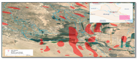
Figure 12: Oil reservoirs under marshlands southern Iraq [78].
Concerning the migrating of Marsh Arabs issue [73], It is interesting to know that those (Marshlands Arabs) kept migrating since the eighties to date due to war operations and the continuous decline of marshlands water areas, depth, and quality [84] [85].The International Organization on Migration (IOM) in 2019 published a report with numbers of families migrated from marshlands in Nasiriya, Umara, and Basra [84]. The report cleared out that as of January 2019, 100 locations were identified as facing water scarcity, 58 locations in Missan Governorate, 22 in Muthanna, 11 in Basra and 9 in Thi-Qar. And that 5,347 families were displaced from the four governorates of Missan, Muthanna, Thi-Qar and Basra [85]. Figures of the report show that most of these migration locations are within Marshland areas and villages, figure. These migration waves never stopped specially through the nineties (when Turkey filled and operated 13 dams and HEPP of GAP project in one decade, including Ataturk mega dam). This migration continued after 2003, according to published reports of their suffering from lack of services and increase of marshes water salinity to more than (6000- 10000) ppm [87]. Water salinity more than 5000 ppm kills their animals (buffalos or Jamose), major source of their living [86]. After 2003, the Americans and UN organizations switched the cause of migrations from force migration by Iraqi government into (migration from drought related water scarcity).
Serious environmental impacts have resulted from impairment of downstream natural flow of Tigris and Euphrates rivers by GAP projects including the increase of losing about 250 Km² of Iraq’s fertile land annually to desertification [87], that means about 750000 Hectare of good agriculture land have already been lost to desertification last three decades. In addition to other serious ecological and socioeconomic impacts.
Iraq is facing higher frequency of dust and sandstorms from 24 day/year in (1950-1990) to 200-220 day/year in (2008-2009) [87].
The destruction of thousands of years old date palm forests along Tigris and Euphrates floodplains with major reduction of the numbers of date palm trees from about 32 million during the sixties to only 13.9 million in 2011 [88]. Main reason is the recession of the Mesopotamian floodplain area associated with the decline of the two rivers main annual water flow in Iraq, and the elimination of seasonal flood waves by dams controlled flow. These seasonal flood waves used to wash the soil from accumulated salts and recharge floodplains shallow ground water aquifers necessary to maintain dates growth in certain time span.
The amount of surface water share available per person annually in Iraq fell from (1540) to (870.8) m³/year [16] in only less than one decade, figure 13.
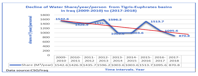
Figure 13: Decline of surface water share/ person /year from (2009- 2018)[16]
*
Note to readers: Please click the share buttons above or below. Follow us on Instagram, @globalresearch_crg and Twitter at @crglobalization. Feel free to repost and share widely Global Research articles.
Prof Souad N. Al-Azzawi, award-winning Iraqi engineer and environmentalist, distinguished scholar, (former) professor of environmental engineering at the University of Baghdad.
She is a Research Associate of the Centre for Research on Globalization (CRG).
Notes
[1] USGS, 2019. How Much Water is There on Earth? United states Geological Survey, Water Science School . November 13, 2019.
[2] Nilsson C. and Jansson R., 1995. Floristic Differences Between Riparian Corridors of Regulated and Free-Flowing Boreal Rivers. Regulated Rivers Research & Management, 11(1):55 – 66. September 1995. DOI: 10.1002/rrr.3450110106
[3] Molle F., 2017. River Basin Management and Development. The International Encyclopedia of Geography. John Whiley and Sons, Ltd. DOI: 10.1002/9781118786352.wbieg0907. https://horizon.documentation.ird.fr/exl-doc/pleins_textes/divers17-10/010070802.pdf.[4]. Reap R. 2012. Summary Notes of the International Water Law and UN Watercourses Convention Regional Awareness Workshop. Cambodia May 10-11, 2012. Hatfield Consultants. http://www.unwatercoursesconvention.org/images/2012/10/Summary-report-of-the-Regional-Awareness-Raising-Workshop_May10_20120530-1.pdf
[5] GOLMOHAMMADI V., 2021.Water Scarcity in the Middle East: Beyond an environmental risk. OBSERVER REASEARCH FOUNDATION (ORF). May 06/2021.https://www.orfonline.org/expert-speak/water-scarcity-middle-east-beyond-environmental-risk/#.
[6] FAO 2018, DROUGHT IN IRAQ. HTTPS://FSCLUSTER.ORG/SITES/DEFAULT/FILES/DOCUMENTS/2018_FAO_PPT_ON_DROUGHT.PDF.
[7] Ronayne M. 2005. The Cultural and Environmental Impact of Large Dams in Southeast Turkey. Fact-Finding Mission Report. National University of Ireland, Galway. Page 19.
[8] UN-ESCWA and BGR (United Nations Economic and Social Commission for Western Asia; Bundesanstalt für Geowissenschaften und Rohstoffe). 2013. Inventory of Shared Water Resources in Western Asia. Beirut. page 79.
[9] Meijer L. ,2018. “The Southeastern Anatolia Project (GAP): water, counterinsurgency, and conflict”. By Course “Food Security in International Politics: The Middle East and Africa” Taught by Dr Eckart Woertz Spring 2018.HTTPS://WWW.SCIENCESPO.FR/KUWAIT-PROGRAM/WP-CONTENT/UPLOADS/2018/11/LAURA-MEIJER-SOUTHEASTERN-ANATOLIA-PROJECT.PDF.
[10] Downstream Impacts of Turkish Dam Construction on Syria and Iraq:
Joint Report of Fact-Finding Mission to Syria and Iraq. jointly researched, written and published by Kurdish Human Rights Project. The Ilisu Dam Campaign. The Corner House, July 2002. https://www.oieau.org/eaudoc/system/files/documents/40/204634/204634_doc.pdf.
[11] Nomas, H.B. 2015. Hydrological changes of lower Euphrates River basin from Nasiriya city to Qurna. Journal of geographic research, No 22, pp.145-167.[ in Arabic]
[12] UN-IAU 2010. Water in Iraq factsheet. Interagency information and analysis unit. Oct. 2010. https://reliefweb.int/sites/reliefweb.int/files/resources/A1F9733337B9CE83C12577C90032CCED-Full_Report.pdf.
[13] Erdem M., 2003. The Tigris-Euphrates Rivers Controversy and the Role of International Law. Journal of international affairs, Year 2003, Volume 8, Issue 1, 1 – 14, 01.03.2003.
[14] Durobi A. 2011.Advantages of Cooperation between Tigris and Euphrates River Basins Countries for Optimal Use Of their Water Resources. Scientific Forum for Water Security Strategy. Naif University for Security Sciences. Riyadh. Saudi Arabia. Dec.21, 2011. [ In Arabic]. HTTPS://WWW.MEREFA2000.COM/2019/09/BLOG-POST_32.HTML
[15] Alan L. Flint, Lorraine E. Flint, Jennifer A. Curtis, and David C. Buesch. A Preliminary Water Balance Model for the Tigris and Euphrates River system. US Geological Survey, January 2010. https://www.researchgate.net/publication/252321941.
[16] CSO/Iraq. Central statistical organization. Ministry of planning. Environmental statistics of Iraq for the years from (2009, 2010, 2011, 2012, 2013, 2014, 2015, 2016, 2017, 2018, 2019). Baghdad, Iraq. [in Arabic]
[17] Lafta A. A. 2021. Estimation of Tidal Excursion Length Along The Shatt Al-Arab Estuary, Southern IRAQ. Vietnam Journal of Science and Technology 59 (1) (2021) 79-89. doi:10.15625/2525-2518/59/1/15433.
[18] Nomas, H. B. 2006. Shatt Al-Arab, Water Future and alternative water developments. Journal of Basra Literature. No 41 (181-206). In Arabic.[In Arabic].
[19] Al Mahmoud K. H., 2020. Referenced Analysis to discharges and Salinity Records of Shatt Al Arab. Iraqi Journal of Aquiculture. Vol. 17, No.1. 2020. Pages (11-26). [In Arabic.]
[20] Nomas, H. B. and Gtamiy. H. A. 2016. Hydrological Properties of Karun and Karkheh rivers / Southwest of Iran. Journal of Arabic Gulf. Vol. 44, No. 3-4. PP. 28-55. Basra, Iraq. 2016. In Arabic.
[21] Badawi Tamer, 2020. Iran’s Upstream Hegemony and Its Water Policies Towards Iraq. Italian Institute of International Political Studies, ISPI.26 Feb. 2020.https://www.ispionline.it/en/pubblicazione/irans-upstream-hegemony-and-its-water-policies-towards-iraq-25173.
[22] Save the Tigris Campaign. 2020. Damming the Kurdistan Region of Iraq: Structural gaps in the KRG dam construction policies. A report by Save the Tigris Campaign. June 2020. 86 pages.
[23] Counter Current – GegenStrömung, 2011. Dam construction in Turkey and its impact on economic, cultural, and social rights, 2011. Submission to the UN Committee on Economic, Social and Cultural Rights for its 46th Session, 2 – 20 May 2011.PP. 5. https://tbinternet.ohchr.org/Treaties/CESCR/Shared%20Documents/TUR/INT_CESCR_NGO_TUR_46_10201_E.pdf.
[24] Stahl, D., 2014. The Two Rivers: Water, Development and Politics in the Tigris-Euphrates Basin, 1920-1975. PhD Thesis, Colombia University. 263 pages. Pages 93, 228,
[25] Ismael T. Y. 2016. The International Relations of the Middle East in the 21st Century. Routledge Pub. NY. USA.
[26] Jones C., Sultan M., Yan E., Milewski A., Hussein M., Al-Dousari A., Al-Kaisy S., Becker R., 2008. Hydrologic impacts of engineering projects on the Tigris–Euphrates system and its marshlands. Journal of Hydrology (2008) 353, (59– 75).
[27] Brown M. E., 1979. The Nationalization of the Iraqi Petroleum Company. International Journal of Middle East Studies. Vol. 10, No. 1 (Feb., 1979), pp. 107-124. Published By: Cambridge University Press.
[28] Ronayne M. 2005. The Cultural and Environmental Impact of Large Dams in Southeast Turkey. Fact-Finding Mission Report. National University of Ireland, Galway. Page 19.
[29] HRW (2019) Basra is Thirsty. Iraq’s Failure to Manage the Water Crisis. Human Right Watch. July 22.2019. Iraq’s Failure to Manage the Water Crisis | HRW.
[30] James O. Moermond & Erickson Shirley, 1987. A Survey of the International Law of Rivers. Critical Assay. Denver Journal of International Law. & Policy. Volume 16, No.1. 139 (1987).
[31] Lorenz F. M. and Erickson E. J., 1999. The Euphrates Triangle: Security Implications of the Southeastern Anatolia Project. National Defense University Press Washington, D.C. 55 pages.
[32] Tanzi A. ,1992. INTERNATIONAL LAW AND TRANSBOUNDARY WATER RESOURCES A Framework for Shared Optimal Utilization. Legal Board of the 1992 UNECE Water Convention, University of Bolonia, Italy. Page 142.
[33 ] Kibaroglu A., 2014. An analysis of Turkey’s water diplomacy and its evolving position vis-à-vis international water law. Water International.Volume 40, 2015 – Issue 1.Pages 153-167. https://doi.org/10.1080/02508060.2014.978971
[34 ] Climate diplomacy. Turkey, Syria and Iraq: Conflict over the Euphrates-Tigris. https://climate-diplomacy.org/case-studies/turkey-syria-and-iraq-conflict-over-euphrates-tigris.
[35] Al Taweel R. Z. 2010. Political and Economical Impacts of Water. Zahran House for Publishing and Distribution. Amman, Jordan. Pages ????. In Arabic.
[36] Unver O. 2001. Southeastern Turkey: Sustainable Development and Foreign GAP Regional Development Administration. Prepared for the OECD-China Conference on FDI in China’s Regional Development. 11-12 October 2001.https://www.oecd.org/investment/investmentfordevelopment/2350280.pdf
[37] Wu H., Dorton R. & Borthwick A., 2015. Defining and measuring river basin sustainability: a case study of the Yellow River. WIT Transactions on The Built Environment, Vol 168, © 2015 WIT Press. doi:10.2495/SD150331. www.witpress.com, ISSN 1743-3509 (on-line).
[38] Bilgen A. (2018): Turkey’s Southeastern Anatolia Project (GAP): a qualitative review of the literature, British Journal of Middle Eastern Studies. To link to this article: https://doi.org/10.1080/13530194.2018.1549978.
[39] Abdullah, A. (2016). Modelling Approaches to Understand Salinity Variations in a Highly Dynamic Tidal River: the case of the Shatt al-Arab River. CRC Press / Balkema – Taylor & Francis Group.
[40] Al-Khayat H. 1975. Geography of Marshlands and Swamps southern Iraq. UNESCO, Institute of Arabic Research and Studies. In Arabic. International Publishing, Cairo. Egypt. 226 pages. In Arabic.
[41] Maatouq, S. 2015. hydrochemical changes of southern Iraq marshlands and its environmental impacts. Journal of Basra Studies. In Arabic. Year eight, No.15. 223-243.
[42] Salmabadi H. and Saeedi M. 2018. Areal fluctuations monitoring of Al-Azim/Al-Havizeh wetland during the 1986–2017 period, using time-series Landsat data. The Second International Conference on Strategic ideas for Architecture, Urbanism, Geography and Environment, Mashhad, Iran.
[43] US-EPA, 2015. Connectivity of Streams & Wetlands to Downstream Waters: A Review & Synthesis of the Scientific Evidence. EPA/600/R-14/475F | January 2015 | epa.gov/research
[44] Chen Z. Q., Kavvas M. L., Ohara N., Anderson M. L., and Yoon J. 2011. Impact of Water Resources Utilization on the Hydrology of Mesopotamian Marshlands. JOURNAL OF HYDROLOGIC ENGINEERING © ASCE / DECEMBER 2011 / 1083.
[45] FAO. 2009. AQUASTAT Transboundary River Basins – Euphrates-Tigris River Basin. Food and Agriculture Organization of the United Nations (FAO). Rome, Italy.
[46] Siegal M. .1999. Former UN official says sanctions against Iraq amount to ‘genocide’. Cornel Chronical. https://news.cornell.edu/stories/1999/09/former-un-official-says-sanctions-against-iraq-amount-genocide
[47] FAO, 2008. Irrigation in the Middle East region in figures – AQUASTAT Survey 2008. Pages 199-2014.
[48] Malla S, Wieland M. and Straubhaar S., 2006. Monitoring Ataturk dam. 17 October 2006https://www.waterpowermagazine.com/features/featuremonitoring-ataturk-dam.
[49] Yasir R. A., Rahi K. A., Abudi Z. N. 2018. Water Budget for Abu Zirig Marsh in Southern Iraq. Journal of Engineering and Sustainable Development. Vol. 20, No.01, January 2018. ISSN 2520-0917. www.jeasd.org.https://iasj.net/iasj/download/3a58a96398e5a9c1.
[50] Khalaf A. G., Mohammed G. H., Jassem A. A. 2016. Monitoring Change of Marshes In South of Iraq by Using Image Processing Techniques for Landsat Images through Period From 1990 to 2015. Journal of Engineering and Technology. Volume 34. No. 9.Sec. A. Pages 261-274. Baghdad. Iraq.
[51] Abdul Jabbar A.2018. Use of Remote Sensing Application to Identify Desertification Zones in the Southern Iraq Marshes. In Arabic. Vol.22, No 2(sec.3), March 2018. ISSN 2520-0917. 10.31272/jeasd.2018.2.42.
[52] Kadhim S. N., Abdul Karim I. K., and Gatea H. H. 2011. Use of Unified Remote Sensing Data with GIS to Monitor Change in Marshlands Environment in Southern Iraq. Journal of Mustansiriya Sciences. Vol.22, No.4. (130-142). Page 140. In Arabic.
[53] CRIM, 2012. Auditing Report. Duties of Center of Recovery of Iraqi Marshlands (CRIM) in Managing, Coordinating, and Monitoring the Execution of the Recovery of Marshlands. 21 pages report.https://www.environmental-auditing.org/media/4073/iraq_f_ar_center-for-restoration-of-marshes.pdf.
[54] IUCN, 2016. WORLD HERITAGE NOMINATION – IUCN TECHNICAL EVALUATION THE AHWAR OF SOUTHERN IRAQ: REFUGE OF BIODIVERSITY AND THE RELICT LANDSCAPE OF THE MESOPOTAMIAN CITIES (IRAQ) – ID No. 1481.
[55] Manssory F., 2009.The Ezz River and Its Effect on Shatt Al Arab Sediment Discharge. University of Thi-Qar Journal, 2009, Volume 4, Issue 4, pages (113-121). Thi-Qar, Iraq. Page.117.
[56] FAO’s Global Information System on Water and Agriculture, 2008. Country Profile – Iran (Islamic Republic of Iran.).https://www.fao.org/aquastat/en/countries-and-basins/country-profiles/country/IRN.
[57] Al-Asadi S. A. and Al-Maatouq S. S. 2013.Utilization of Hawaiza marsh potential for natural Protectorates. Basra Literature Journal. No. 64. University of Basra. Basra, Iraq. Page 271.
[58] Fouladavand S. and Sayyad G. A. 2015. The Impact of Karkheh Dam Construction on Reducing the Extent of Wetlands of Hoor-Alazim. Journal of Water Resources and Ocean Science. Volume 4, Issue 2, April 2015, Pages: 33-38.
[59] WHO/EHA/96.1, 1996. The Health Conditions of The Population in Iraq Since the Gulf Crises. Impact on the environment because of increased agricultural activities. https://apps.who.int/disasters/repo/5249.html.
[60] James Rubin, 1999. Starving Iraq: one humanitarian disaster we can stop. US Department of State spokesman, daily press briefing, December 1, 1997. Campaign Against Sanctions on Iraq. March 1999. http://www.casi.org.uk/briefing/pamp_ed1.html.
[61] Al-Imara F.J.M. and Jawad A. M., 1994. Physico-Chemical Parameters of Southern Iraq Water, Northwest Arabian Gulf. Marina Mesopotanica, Vol.9 (1): Pages 1-12. Basra Marin Center. Basra, Iraq. Page 4.
[62] Kliot, N., Water Resources and Conflict in the Middle East, London: Routledge, 1994, p. 118
[63] WHO, 2011. Guidelines for Drinking-water Quality FOURTH EDITION. World Health Organization. ISBN 978 92 4 154815 1.
[64] Tippet-Abbett-Mccarthy, Stratton Engineering, Inc. 1958. Summary of Definite Project Reports for Basrah Vicinity.Irrigation and Drainage Projects. Ministry of Development, Development Board. Government of Iraq. Baghdad. PII.I-II-7, III-I-III-2and Plate I.
[65] Nomas H. B. and Ramadan B. Y., 1998. Evaluation of Ezz River in Preserving and Develop Water Resource in southern Iraq. Journal of Education College. Mustansiriya University. Number 1. Baghdad. Iraq.
[66] Nomas H. B. and Hashim A. A. 2021. The Al Bada Canal water project: Its Construction Aspects and importance for Drinking water Supply projects of Basra Province. Journal of Education college, Wasit University. Vol. 1. No.44. Aug.2021. Pp. (205-235). In Arabic. https://doi.org/10.31185/eduj.Vol1.Iss44.2288. https://eduj.uowasit.edu.iq/index.php/eduj/article/view/2288.
[67] Almukhtar S., Hamdan A.N.A., and Scholz M. 2020. Assessment of the Effluents of Basra City Main Water Treatment Plants for Drinking and Irrigation Purposes. Water, 12 (12) , e3334. doi:10.3390/w12123334. file:///C:/Users/souad/Downloads/water-12-03334-v2%20(5).pdf.
[68] Al-Rubaie A., Mason M., and Mehdi Z. 2021. Failing Flows: Water Management in Southern Iraq. LSE Middle East Centre Paper Series | 52. July 2021. Middle East Centre. http://eprints.lse.ac.uk/110973/.
[69] Minister of Water Resources Received the Approval of PM Counsel to Convert Bada Canal from Open Canal to Closed one. Water Resources Ministry Website, July 20, 2020. In Arabic.https://mowr.gov.iq/2020/07/22/%D9%88%D8%B2%D9%8A%D8%B1%D8%A7%D9%84%D9%85%D9%88%D8%A7%D8%B1%D8%AF%D8%A7%D9%84%D9%85%D8%A7%D8%A6%D9%8A%D8%A9-%D9%8A%D8%B3%D8%AA%D8%AD%D8%B5%D9%84-%D9%85%D9%88%D8%A7%D9%81%D9%82%D8%A9-%D9%85%D8%ACز
[70] Nomas H. B., 2005. The potential water supply for the Rehabilitation in the Southern marshes of Iraq. Marina Mesopotamica, 20(1): 105-126. University of Basra, Basra, Iraq. In Arabic.
[71] AL- MALLAH, I. A. 2014. Assessment of the Environmental, Hydrological and Hydrogeological changes of the Main Drain, Iraq. PhD Thesis. College of Science. University of Basra. Basra, Iraq. 280 pages.
[72] Biswas, A.K. edit. 2014. Middle East from Euphrates-Tigris to Nile. Water Resources Management Series. OXFORD UNIVERSITY PRESS, 1994. Page 84.
[73] Merry, M. (1992), ‘Iraq builds Third River Project despite no-fly zone’, EIR, 19:46, November, http://www.oalib.com/references/14621588.
[74] Al-Jabari M.H. and Al-Nofel B. F. (2001). Saddam River (The Miracle River). General Cultural Affairs House, Baghdad, Iraq.156 pages (In Arabic).
[75] NEDCO. 1983. Tigris Euphrates Main Outfall Drain Project (North of Hor Dalmaj). Netherland Engineering Consultants Final Report, submitted to Ministry of Irrigation. Republic of Iraq.
[76] AL-Amar H. A. S. 2017. A Study the Concentration of Heavy Metals in Water of the Al-Massab Al-Aam Channel (Middle Sector) in Iraq. International Journal of Chem Tech Research. Vol.10 No.2, pp 594-603, 2017. ISSN: 0974-4290, ISSN(Online):2455-9555. Page 595.
[77] Prim Minister Inaugurates the MOD pumping Station in Nasiriya. Press release, from the Cabinet Media Office. Monday Dec.1st. 2008. http://cabinet.iq/ArticleShow.aspx?ID=737.
[78] Dellapenna J. W., 2007. Ecocide and genocide in the Iraqi Marshlands. WIT Transactions on Ecology and the Environment, Vol 104, © 2007 WIT Press. www.witpress.com, ISSN 1743-3541 (on-line). doi:10.2495/RM07038.
[79] Koa J.Y. and Daya J. W. 2004. Impacts of Oil and Gas Activities on Coastal Wetland Loss in The Mississippi Delta. Ocean & Coastal Management 47 (2004) 597–623. Available at: https://www.researchgate.net/publication/237565471_IMPACTS_OF_OIL_AND_GAS_ACTIVITIES_ON_COASTAL_WETLAND_LOSS_IN_THE_MISSISSIPPI_DELTA.
[80] Fanak/ Water, 2017. Marshlands in Twenty’s Century. May 30, 2017. In Arabic. Online. https://water.fanack.com/ar/specials/iraqi-marshes/marshes-20th-century.
[81] Majed Al-Brekan, 2012. “Oil Projects Drying the Marshlands”. Al Hurrah News. May 17. 2012. [In Arabic]. Online. https://www.alhurra.com/iraq/2012/05/17/%D9%85%D8%B3%D8%A4%D9%88%D9%84-%D8%A7%D9%84%D9%85%D8%B4%D8%A7%D8%B1%D9%8A%D8%B9-%D8%A7%D9%84%D9%86%D9%81%D8%B7%D9%8A%D8%A9-%D8%A3%D8%AF%D8%AA-%D8%AA%D8%AC%D9%81%D9%8A%D9%81-%D8%A7%D9%84%D8%A3%D9%87%D9%88%D8%A7%D8%B1.
[82] Al MADA PAPER, 2015. Jasim Al Asadi: Deduction of Areas from Marshlands for Oil Explorations. Online, Dec. 17. 2015. 12:01:00. AM. https://almadapaper.net/view.php?cat=141113. [ In Arabic].
[83] Alsamaraie, 2014: Scientific Study Warns from Further Environmental Pollution in Basra Marshlands Because of Oil Projects. [In Arabic]. Online.
..
[84] IOM, 2019. Water Quantity and Water Quality in Center and South Iraq: A PRELIMINARY ASSESSMENT IN THE CONTEXT OF DISPLACEMENT RISK I. International Migration Organization.
[85] UN-IOM, 2019. ASSESSING WATER SHORTAGE-INDUCED DISPLACEMENT IN MISSAN, MUTHANNA, THI-QAR AND BASRA. International Migration Organization.
[86] Hussain al Amel, 2021. Environmental Organization Suggests Solutions for Increase of Marshlands Water Salinity. Al MADA Paper. Online, Aug. 03, 2021, 11:35:32. Thee Qar. Iraq.. https://almadapaper.net/view.php?cat=243559.
[87] Ministry of Environment , 2016. State of Environment in Iraq. Report 282 pages. Page 4. Republic of Iraq.https://moen.gov.iq/Portals/0/%D8%A7%D9%84%D9%88%D8%A7%D9%82%D8%B9%20%D8%A7%D9%84%D8%A8%D9%8A%D8%A6%D9%8A/%D8%AD%D8%A7%D9%84%D8%A9%20%D8%A7%D9%84%D8%A8%D9%8A%D8%A6%D8%A9%20%D9%81%D9%8A%20%D8%A7%D9%84%D8%B9%D8%B1%D8%A7%D9%82%20%D9%84%D8%B9%D8%A7%D9%85%202016.pdf.
[88] Al Ogaidy K. H. 2011. Towards Better Future for Dates and Palms in Iraq. www.iraqi-datepalms.net.
Featured image: Painting by Abdul-Qadir al-Rassam depicting a scene in Southern Iraq
Appendices
Appendix A: Table I
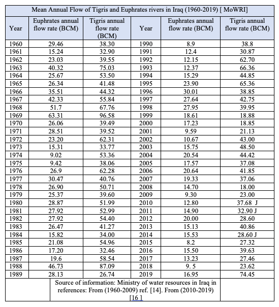
Appendix B: Table II [45]
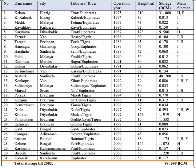
The original source of this article is Global Research
No comments:
Post a Comment